2003 Appalacian Trail hike.
This year, we started our hike at the PA-MD border in the town of Pen Mar, MD. This is the spot where we ended our first annual hike, 2 years ago. This year we continued south from Pen Mar to Crampton Gap, MD, a distance of 30.5 miles on the trail. Our 5-man crew consisted of myself, my brother Brian, our cousin Chris, and our friends Jason and Josh. Incidentally, Josh is newly married this year, leaving only me and Chris to represent on the single tip.
The original plan was to start Sunday night (the 15th) and hike just a couple miles, then do about 10 miles per day and leave Wednesday evening. We arrived in Pen Mar and got on the trail around 9pm Sunday, but proceeded to hike in a big loop for about an hour, and ended up back at the start. Trying again, and this time following the white blazes, we covered about 2 miles before setting up camp for the night.
Sunday night was absolutely silent when we went to sleep, and it was rather disconcerting because you could hear every little (and every loud) movement made by the various forest creatures. We heard a couple not-so-far-away sounds that we couldn't even identify so that freaked us out a bit.
Monday was a beautiful day, probably just about 65° or 70°, and cloudy. We hiked for a couple hours, then stopped by a creek to have lunch and bathe. Well, not bathe exactly... there's only so much you can wash out in the open with your shorts on... but I at least got to wash my hair, face, and sweaty armpits. It's really neat to get clean in a cold creek on a nice warm day.
After lunch we continued on, planning to do about 10 miles total, which would put us 12 miles into our 30.5 mile trip. Josh and Jason apparently have motorized prosthetic legs, because they just take off and are out of sight within seconds, and me, Brian, and Chris come upon them every-so-often when they stop to "rest." Well around 5 pm, they went ahead and didn't stop. After about an hour, we started to wonder and call out to them, but got no response. By 6:30 or 7:00 pm, we had done our 10 miles and then some, so we started to think about setting up for the night. We decided that we'd set up at 8pm if we didn't find them by then.
8pm came and went, and we passed the site of 2 other hikers who said no one had passed by in the past couple hours. We moved a little beyond their site and set up camp. We eventually got Josh on the phone, and learned that him and Jason had stopped and gone off the trail to check out a view, and apparently stayed out there for a while, because we went by them without either group noticing. It turned out that they were a couple miles behind, as me, Brian, and Chris were doing double-time to try and catch up to them. So we camped separately for the night, and in the morning Jason and Josh got up a little earlier and hiked to our site.
Tuesday it rained. All day. We still had 16 miles to go. We covered seven miles from 10am to 12:30 or so, and stopped at the Washington Monument for lunch. This isn't the Washington Monument you're thinking of, in Washington DC. It's a small stone tower erected in Maryland. We ate lunch on the small stone courtyard-type thing behind the monument, and then it started to rain harder. We were disappointed because we'd hoped there might be a pavillion or tables or soda machines or something park-y at this monument, but there wasn't. After eating, we continued down the path (which was on a stone road here) from the monument, and shortly found a nice little covered shelter that would have been perfect for eating lunch and staying dry. Too bad.
Then a little further, we came across a giant pavillion with restrooms, running water, water fountains, and even a Pepsi machine! We all rejoiced.
While resting at the pavillion, we decided that we didn't want to set up our tents and camp in the muddy mess. Our two options were: 1) have a couple guys run ahead without their packs, and hike the 9 miles to the van at the end of the trail, then drive the van back to this pavillion and pick the rest of us up, or 2) instead of hiking 3 more miles and camping, then finishing up the ~6 remaining miles on Wednesday, we'd finish the 9 miles now and be done a day early. We decided on the latter, so we ended up hiking 16 miles on Tuesday.
We were all hurting at this point. For me, it was my feet and achilles tendons... my feet felt like they were on fire, and my tendons were really sore. But I didn't get any blisters nor did I need any moleskin, which most of the guys did, so my sneakers must fit me really well.
Anyway, the last 9 miles were soaking wet and muddy and painful, but the rain made the forest all misty and it was awesome to be there. And we felt like we conquered that section when we arrived at the van at 8:30pm, a day ahead of schedule, having done 30 miles in about 2 days instead of 3. Not to mention the fact that we'd all already scheduled Wednesday off from work, so now we could rest for a day.
PS - it was quite scary to be alone in the woods with 4 guys who'd never seen HomestarRunner or Strong Bad.
 View from the pavillion at Pen Mar, MD, where we started. It wasn't really this bright; I used a long exposure. |
 Same view, exposed more naturally. This is how dark it actually was. |
 A rattlesnake we met on top of a mountain. You can see his head here, but not his rattle. Oh, he showed it to us, but he slithered away before I could get a photo of it. We sure heard it though... and it wasn't a happy sound. He was only about 2 feet long. |

|
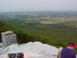
 This overlook is the highest point on the AT in Maryland. And apparently, you can't hang glide from it without asking the secret service first. |

|
 Panning right to left: 1 of 6. |
 Panning right to left: 2 of 6. |
 Panning right to left: 3 of 6. |
 Panning right to left: 4 of 6. |
 Panning right to left: 5 of 6. |
 Panning right to left: 6 of 6. (That is just some random guy; we didn't know him.) |
 Josh standing on one of the little rock ledges on the face of the cliff. |
 Some countryside. |
 Gear. |
 A small grasshoppery creature with long antennae and funny hands. I didn't get a close-up of the funny hands. Sorry. |

|

|
 Brian, Jason, and Chris. |
 A rocky section. |
 A gigantic rock. |
 More rocks... |
 A cave and a crack in the rocks. |
 Walking up the back of another cliff. |
 A small waterfall. |
 The trail crossed this road that was being paved right in front of us. Mmm, fresh asphalt. |
 A creek we crossed, then stopped and had lunch next to, and bathed in. Well, as much as you can bathe with your shorts on, anyway. |

|
 "How far to the next spring, Chris?" "How many miles have we gone today, Chris?" "Why is this uphill so stinking long, Chris??" |
 Don't know what kind of bug that is. Half lightning bug, half cockroach, I think. |
 A frog hiding on a tree stump. |
 We usually cross a few powerlines like this one. |

|

|

|
 Good to know. Thanks, Smokey. |
 There's me! |
 And again! |
 Another small waterfall... we passed quite a few of these. |
 Another powerline, and some really high... grass, or wheat, or whatever that is. |

|

|
 You might not be able to tell in the photo, but this is a really steep climb, probably 35° or 40°. |
 Mountain flora. |
 &c. |
 This section of the trail was really cool and windy and narrow and rocky and pretty. |
 Jason, Brian, and Josh down on another overlook. |
 Chris holdin' it down topside. |
 Brian. |
 Sittin' on top of the world. |
 In Maryland, they build nice bridges for AT hikers. In PA, they pour extra rocks on the trails. |

|

|

|
 Climbed it. |
 We saw tons of white mountain laurel, which happens to be the state flower of PA. |
 A closed one. They are so pretty. |

|
 Another long uphill climb. |
 This is the sign in front of the Washington Monument (not the one in DC). Sadly, there are 2 grammatical errors on it. And it refers to the town as "Boonesboro," but the stone plaque on the back of the actual monument says "Boonsboro." Hm. |
 That's the monument. It's a ~2 story cylinder with a spiral stone staircase that goes up to the top, which is open. It's almost like a lookout tower. The door is an iron gate. |
 Same monument, same water drops on my lens. |
 The backside of the monument faces a big field of rocks on a downhill slope, and it has this carved stone plaque in it. |

|
 This is later in the day of day 2. It rained all day. |

|

|

|

|

|

|

|

|

|

|

|

|

|
 Guerillas in the mist... oh wait, that's just Brian. |
 More mountain laurel and a really steep climb, about 45° here. This climb went on (though not always this steep) for 2 miles. It was tough. |
 Even though it kinda stank to be hiking in the pouring rain, it was really misty and pretty in the forest. |

|
 I love this photo. |
 What a yucky, muddy creek! Oh wait, that's the trail. |
 That's me! (Hey, when you're the cameraman, you do what you can to get photos of yourself.) |
 (video)
|
 (video)
|
.jpg) (video)
|