« previous: Why You Can't Get Sunburn Near Sunrise And Sunset | next: What the Government is Really Feeding Us »
Kayaking on the Schuylkill River
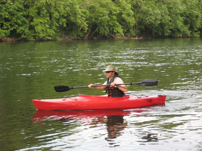
Last Saturday I kayaked in the Schuylkill River for the first time, and it was pretty awesome. Kim had bought me this sweet kayak for my birthday last winter, and I finally got a roof rack for it a couple weeks ago, so this was its maiden voyage.

I had only kayaked a few times before: on a lake near Ricketts Glen, on a river in the Bahamas, and on the ocean/bay in Cape Cod. Those times were all in rented kayaks and with other people; this time it was just me and the Schuylkill.
It was only in the past couple weeks, while researching places to kayak, that I discovered the Water Trails guides, including the Schuylkill Water Trail map. This is unlike every other standard/park/hiking map I’ve used, in that it shows all the bridges, dams, and potential hazards in the course of the river. And it also shows all the public landings that you can use to put in or take out of the river.
I put in at the Union Township landing, which I had never even heard of before seeing it on the Water Trail map. You access it via a tiny unnamed road off of route 724 that goes right between Monty’s Mulch and Tim’s Ugly Mug, and which I’d always assumed was part of one of those businesses, since there’s no street sign on it or anything. Only once you turn onto this tiny road and drive a bit do you come upon a sign declaring the existence of the landing. Update: sometime in late 2011 or early 2012, they put up a nice big sign for this landing, along with a new road, parking lot, and a couple of restrooms, so it’s now very easy to find.
Mom rode with me to the landing, so that she could then take my car back to the take-out point (Pottstown Riverfront Park) so it’d be there when I finished. She took some photos and videos of the launch, and she ended up waiting for me at the end to take some there too -- what a mom!
The kayaking trip was 8 miles long, and it lasted 2 hours. As I note in one of the videos, I was moving at about 4-6 miles per hour when paddling, and about 2 mph when I just sat back and let the river do the work.
During the trip, I was struck by how peaceful the river is, and also how empty it was. In the whole 8 miles, I saw only 6 other groups of people: 4 dudes in an inflatable tube on a Schuylkill River Outdoors trip; a guy in the river fly-fishing; a man and his small kids on one of the landings; and 3 rowboats with motors, each containing two fishermen. I mean, I’m kinda shocked that I’ve never spent any time in the river before (other than a few water-skiing/kneeboarding trips with my neighbors back in the mid-90s), and it just seems crazy to me that in the middle of a nice hot Saturday, so few people were out there enjoying the water.
I was also impressed by how clean the Schuylkill is, at least compared to what I think is the common view of it being a dirty river. The water itself was nice and clear (of course I checked the Philly RiverCast before getting in), and I only saw maybe half a dozen pieces of litter in the entire trip. There were however quite few tires on the bottom: I must’ve seen a dozen or more in the course of the 8 miles I paddled. If I had one of those powered rowboats, I might try to pick up a tire each time I went out on the water, to eventually get rid of all of them.
All in all it was a great trip, and I can’t wait to do it again. Don’t forget to check out the photos and videos that mom and I took before/during/after the trip.
Next kayak trip: Schuylkill River Kayaking from Pottstown to Linfield.
Comments:
Reply to this message here:
[ Home – Create Post – Archives – Login – CMS by Encodable ]