Yam Berries!
 Have you ever heard of Chinese yam? I hadn’t either until I saw it on the Food Forest Farm website.
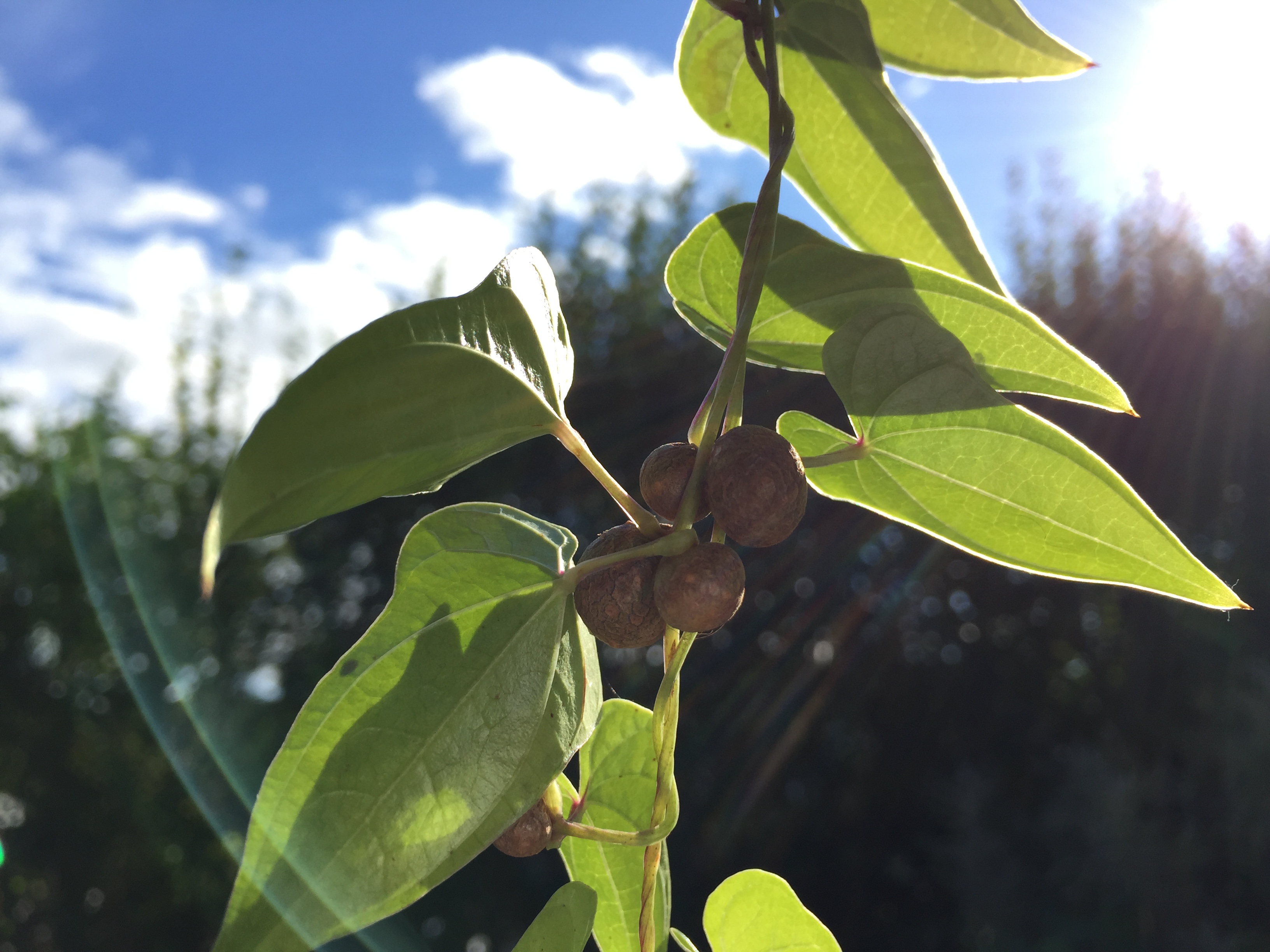
It’s essentially a perennial potato, but it gives you two kinds of potatoes: one huge potato that grows underground to be harvested every few years, plus an annual crop of "yamberries" that grow on the vines in late summer.
I planted some chinese yam in April this year, and by August I had a few 5-foot vines that were covered in a few hundred yam berries.
These yam berries are tiny (a half-inch or so), but there are tons of them, and they are delicious! Just fry them up in butter and they’re basically like crunchy little french fries or homefries.
They are also very easy: no cleaning required since they grow above ground, no peeling, and they fall right off the vine.
Did I mention that chinese yam is perennial? And from what I’ve read, it also grows and spreads like a weed. So it’s super easy to grow: plant it once, and you get free potatoes forever.
Win-win! Go get some!
Steamboat Springs Adventures
It’s summertime again, which always makes me wish that we were out in Colorado. I was browsing some of my previous photos, and realized that I never finished posting the photos from our last trip to Steamboat, in the summer of 2010.
Actually, last summer (a year after the trip) I did finish sifting through my 500+ photos and videos from the trip, and then I posted them, but I marked the set as "hidden", I think because I still wanted to write up a blog post about it?
Well, I never got around to that, but I did at least caption the photos, so the story is pretty much all there anyway. So check them out:
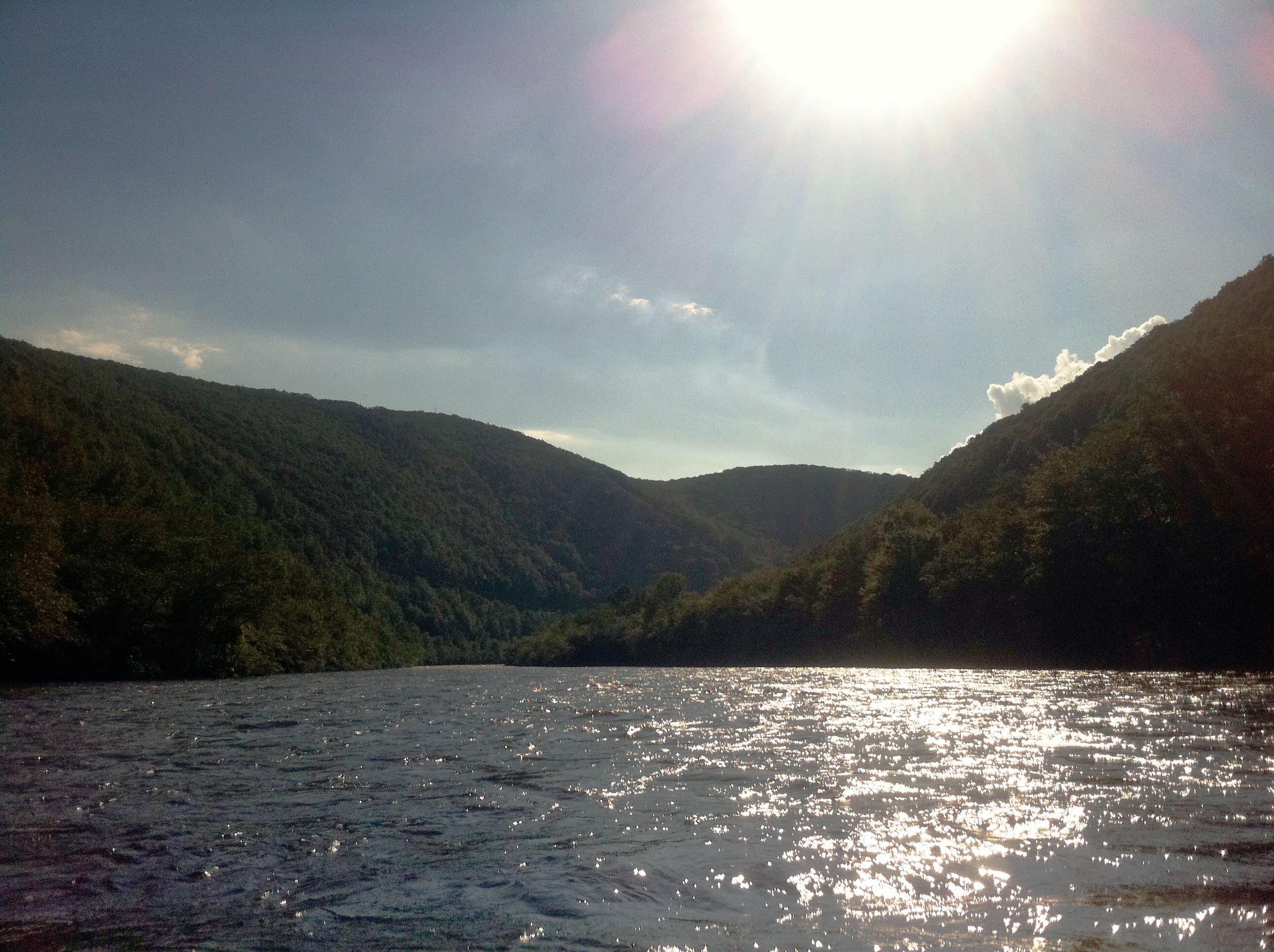
Exciting Schuylkill River Kayaking: Leesport to Elper's Landing
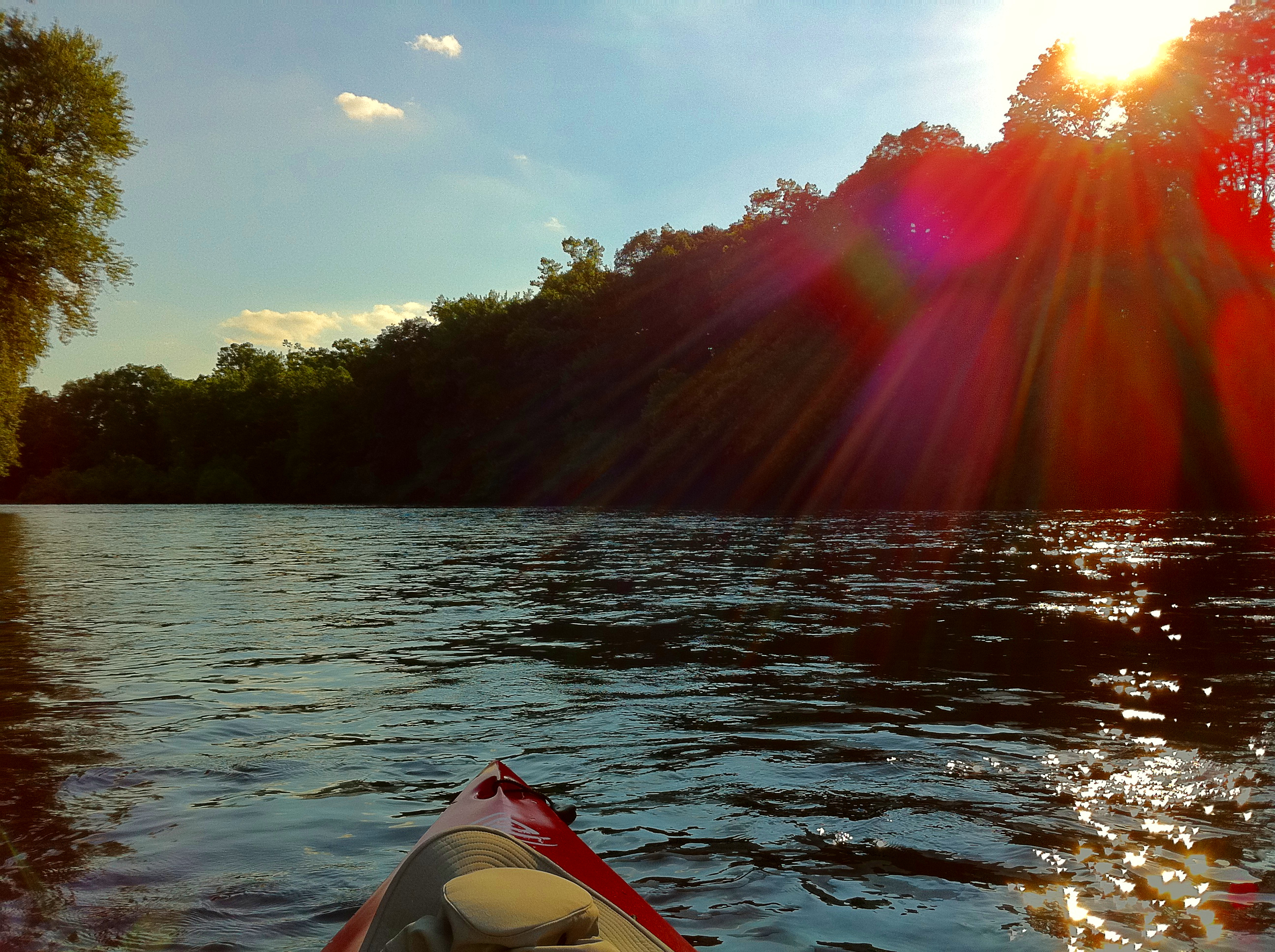
Based on my previous posts about kayaking on the Schuylkill River, you might think that all Schuylkill River kayaking is exciting. Well, that depends. If you’ve never really kayaked much before, or never on moving water, then the Schuylkill is indeed exciting. And even on sections that aren’t quite exciting, it’s still just really nice to get out onto the river on a warm and sunny day.
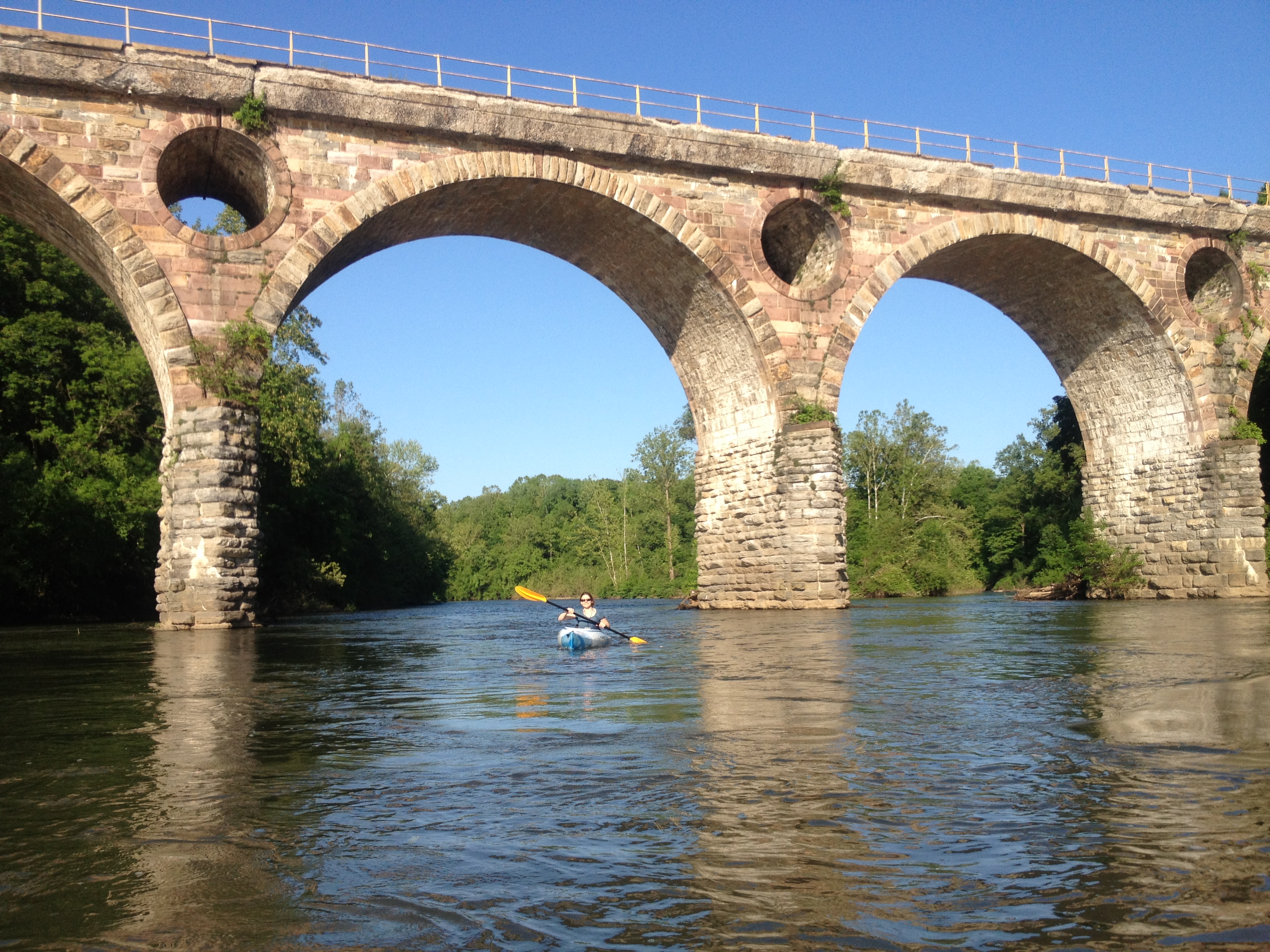
But some sections are more fun than others, as we found out last weekend when we kayaked from Leesport to Elper’s Landing. Most of the sections I’d previously kayaked were entirely flat and calm and wide-open, with the exception of the really cool (but alas really short) side-channel in Birdsboro. But this Leesport section has tons of riffles (basically mini-rapids) and even one or two genuine rapids -- almost certainly just class I, but still, enough to send a wave crashing into my chest as I crossed them, which is so fun.
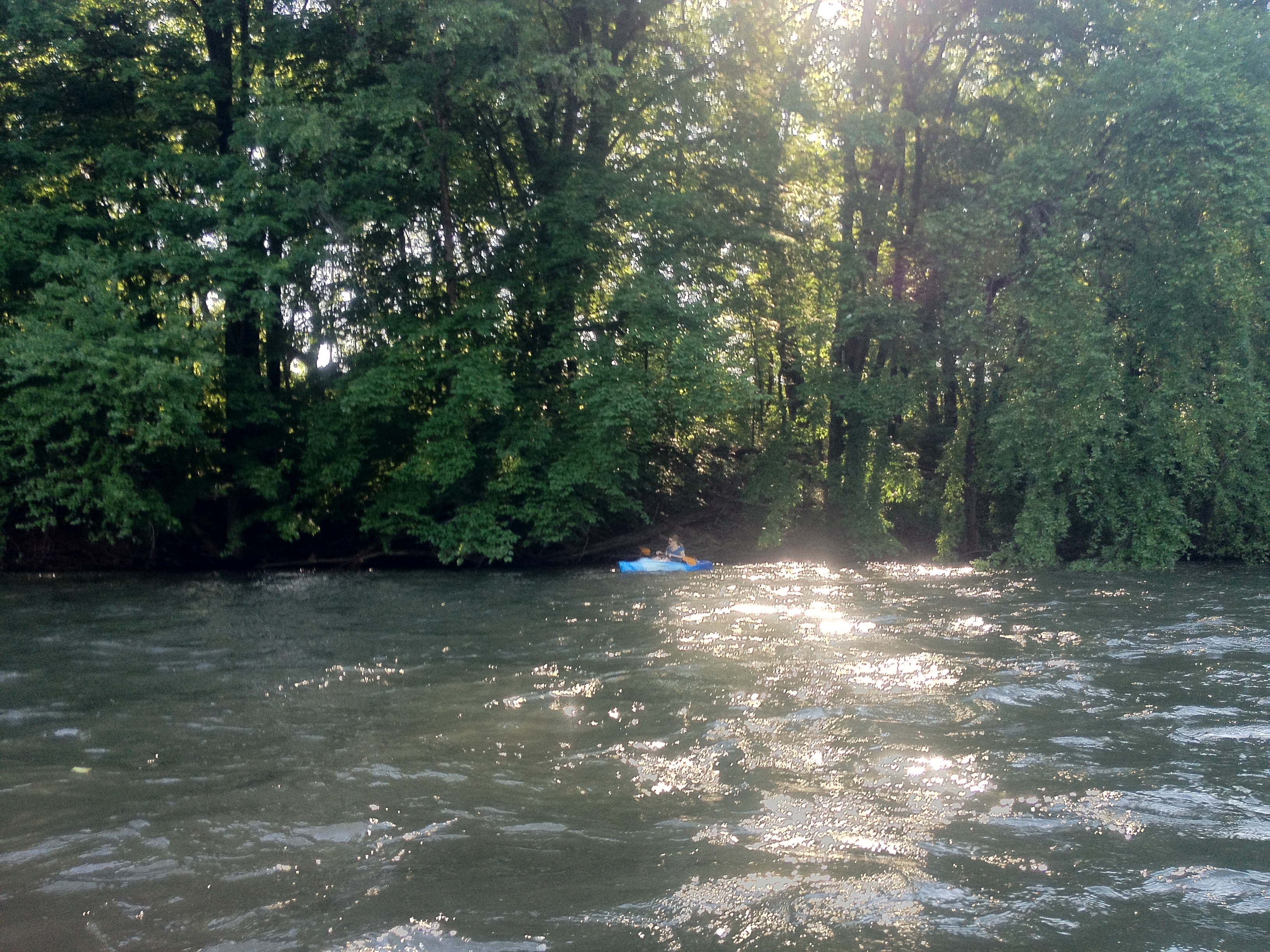
This section also has many trees along its banks whose branches hang down over the water, so you can paddle over and float under the trees and feel like you’re in the jungle. In some spots there are also houses with neat decks right along the water, which I always enjoy checking out as we float by; other spots had big rock walls along the sides. And this stretch of river is also pretty windy, which makes it more interesting than the long straight stretches.
The put-in location is behind the post office in Leesport. We parked in the grass behind the post office, where some other cars were already parked. The take-out is called Elper’s Landing, which is a bit beyond Reading Boat Works; it’s not hard to find, but there aren’t any signs for it, and there are several Keep Out signs along the way for private driveways branching off the road, so just keep on the non-signed road until you get to the landing.
Here’s the GPS map of our route:
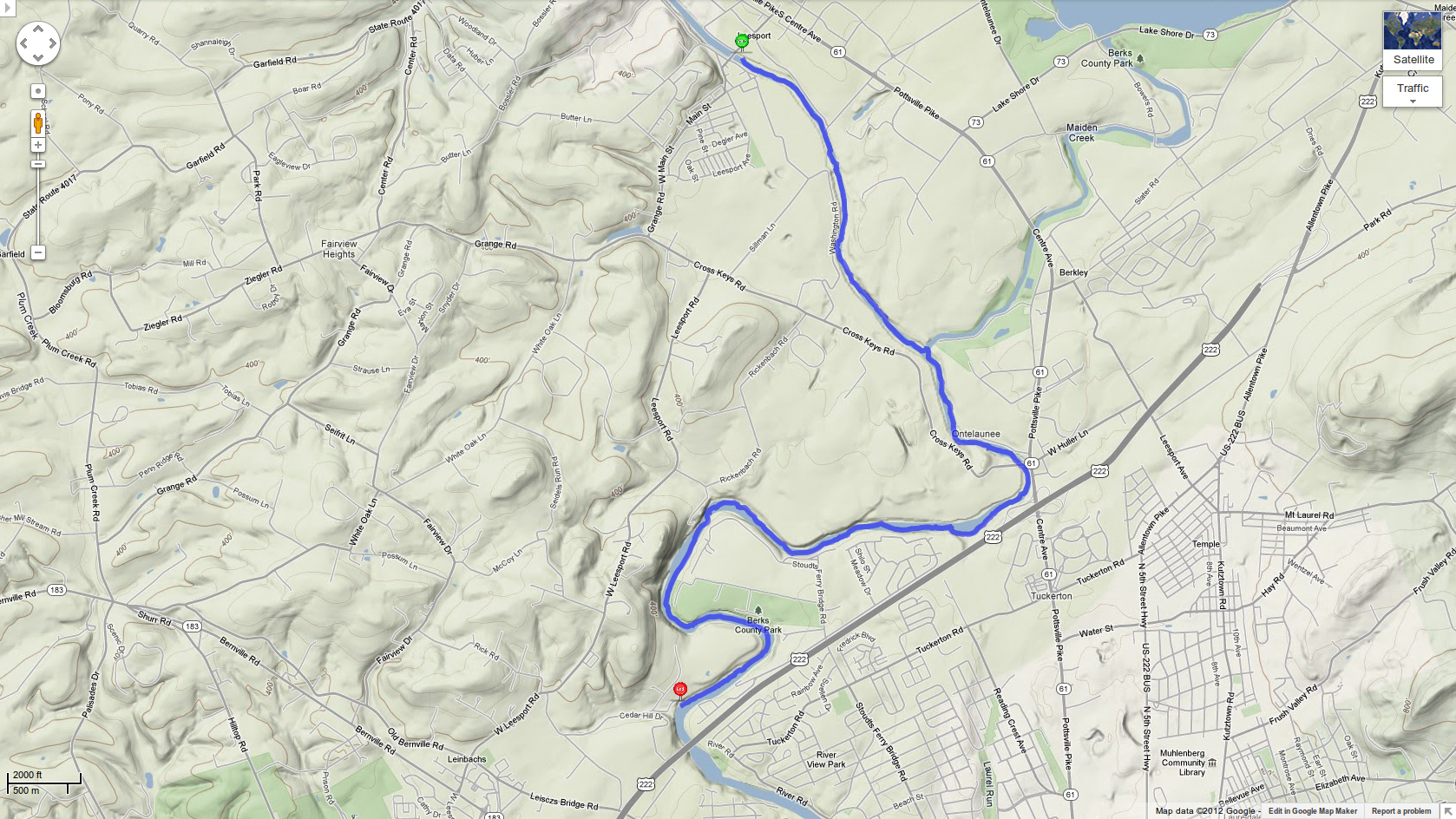
Trip stats: date: 20120519-1704; duration: 110 min; distance: 6.86 mi; river discharge: 1280 cfs; water temperature: 67F; weather: sunny and 80F; map: Schuylkill River Water Trail.
Previous kayak trip: Kayaking the Lehigh River from Jim Thorpe to Lehighton.Next kayak trip: coming soon!
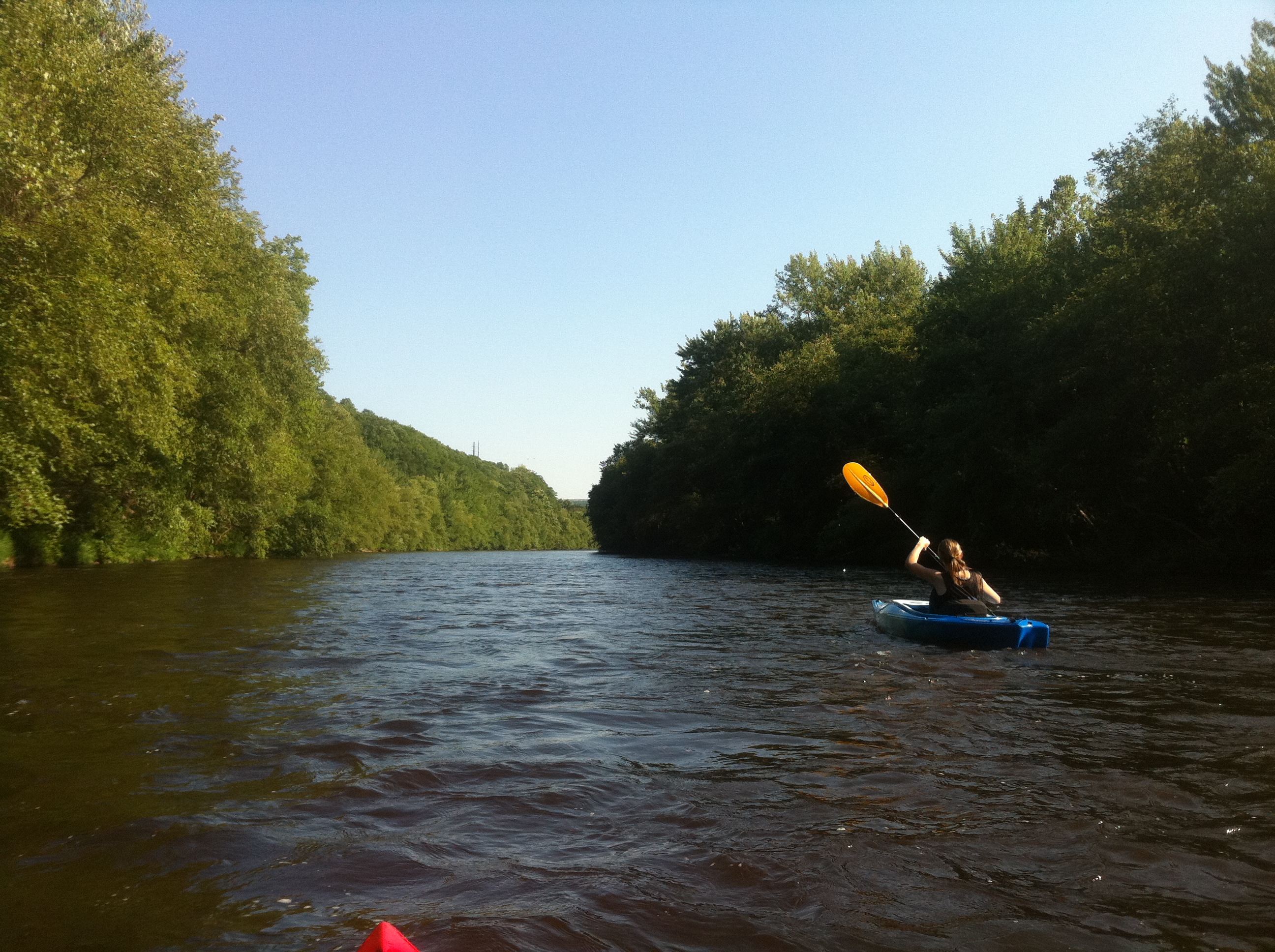
Kayaking the Lehigh River from Jim Thorpe to Lehighton
After our first Lehigh River kayak trip went so swimmingly, we were psyched to go back again. The class I rapids had been no problem at all -- very fun actually -- in our recreational kayaks, and I planned our next trip to be an extension of the same route that would also include some short class II rapids. So whereas last time we did about half of the route from Jim Thorpe to Lehighton, this time we did the whole thing.
There are two class II rapids on this route, the two shown in yellow at the top of the Weissport Canal Loop map. According to American Whitewater, the first one is Bear Trap rapids; I can’t find a name for the second one, under the railroad bridge.
We navigated these rapids easily (as you can see in the videos) in our recreational kayaks, an Emotion Glide and a Perception Sport Sound 9.5. The water level was very high during our run -- about 4000 cfs, compared to ~500-1500 cfs normally -- because of a larger-than-normal dam release to make room in the reservoir for the expected rain from Hurricane Irene, hitting in the next couple of days. This high water level might have made the rapids easier, because we didn’t hit, nor even see, any rocks at all in the rapids; but we also went back a week later and did this same run again at a normal river level, and again had no problems.
I don’t think these kayaks would do well up in the Lehigh Gorge with the class III rapids, because they can’t be quickly turned, nor unrolled, the way whitewater kayaks can. But being able to do class IIs opens up a pretty large amount of the Lehigh River below the gorge, so we have lots more yakking to look forward to!
Check out all the photos and videos from this run.
Previous kayak trip: Kayaking the Lehigh River: Weissport Canal Loop.
Bonus kayak trip: Kayaking the Hiwassee River in Tennessee.
Next kayak trip: Exciting Schuylkill River Kayaking: Leesport to Elper’s Landing.
Forecast Mix-Up
Hey, that’s not the forecast I ordered:
I was thinking more along these lines:

180 Degrees South
I love this movie. I guess it’s a couple years old now, but I only just recently discovered it. It’s overflowing with breathtaking shots of beautiful mountains and oceans. It’s got a great soundtrack. And it tells interesting stories, some small and some large, in the lives of a few rock climbers, surfers, explorers, and just regular people in interesting places.
Watch it on Netflix streaming on your TiVo, Apple TV, iPad, Roku, etc; or buy it on Amazon.
(Note: the trailers on the website really don’t do it justice, especially the "Original Trailer". And they sort of make it seem overly political, which it’s totally not.)
Mystery Animal Noise
Some animal out in our yard/woods makes these strange noises at night. I don’t know if it’s every night, but I hear it probably a few times a week at least. What is it?
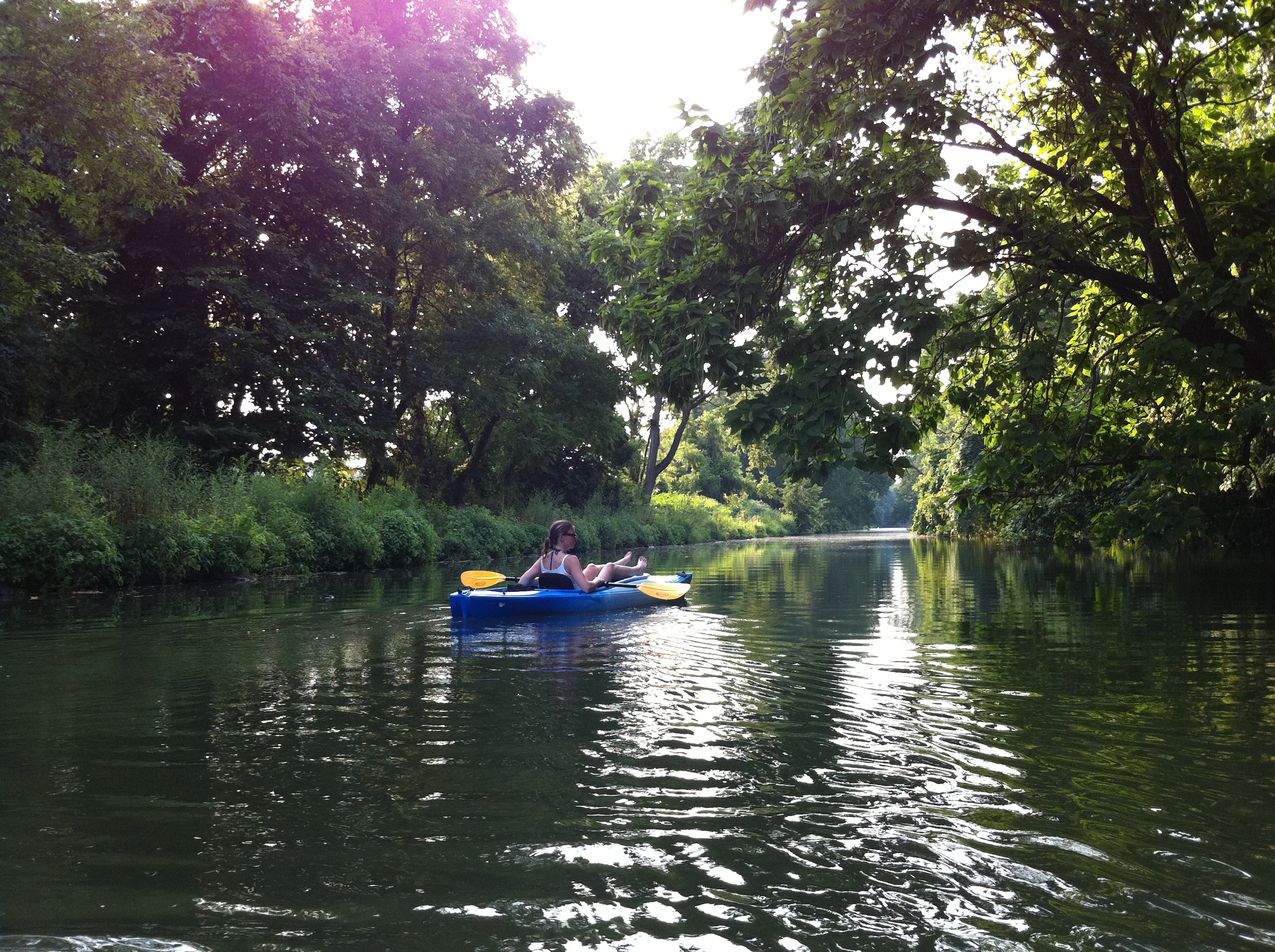
Kayaking the Lehigh River: Weissport Canal Loop
Well, it may have ruined me for the Schuylkill, but the Lehigh River is an amazing place to kayak. Kim and I paddled the short Weissport canal loop on Saturday, and it was one of the most fun things we’ve ever done.
For this loop, you start at the Canal Street parking lot, where you get into the canal and head north. This canal is much cleaner and less stagnant than the one on the Lock 60 loop on the Schuylkill River. It’s got nice stretches full of huge lily pads, and much of the bottom is covered with these long, soft, pine-needley plants whose arms reach up and wave as you pass by. It’s also cool: on this 90-degree day, the river was about 73F, and the canal wasn’t much warmer than that.
The one downside to the canal is the portages: in the less than 2 miles that we were on it, there were 3 spots where we had to get out and drag the kayaks over land. The first one is barely 5 minutes into the trip, and the portage distance is maybe 10 feet. The second one is about 15 minutes later, and it’s a few dozen yards. The third portage is referred to on the map as the "last canal portage", and indeed, it appeared that the canal ended at this point: it got really shallow and then turned into a very small stream. There is a walking trail (the D & L Trail) all along the route between the canal and the river, and we had to get out and drag the kayaks on this trail about 500 feet upstream until we found a spot where we could access the river.
My one major gripe about this loop is that, based on the official-seeming map on the Wildlands Conservancy website, I expected the transition location from canal to river to be at least easy to spot, perhaps even marked in some way. But that wasn’t the case at all. For one thing, the canal kind of just ends, and although the trail is still there along the left bank, there’s no easy spot to take out at. In fact the one spot that looked like it might be a good take-out location was covered in hay with new grass growing up through it, as if they decidedly did not want you to use it as a take-out. But most of the rest of this northern stretch is full of trees and overgrowth that would be tough to get through. And then, when you finally do manage to get up onto the trail, you find a fence along the lefthand side, between the trail and the river -- again, as if they really don’t want people to do this loop. The reason we walked 500 feet upstream to get into the river is that, in addition to the map and my GPS seeming to indicate that that was the spot, we also had to walk about that far just to get beyond the fence.
Rapids!
But griping aside, when we finally did get into the river, holy cow was it fun! There were class-I rapids right at the put-in, and there were ye-haws all around. This was our first time on whitewater (other than a bit of rapids on the Yampa River in Colorado, but that was in a raft) and it was really exciting. I chose this loop because it only has class-I rapids, and only 4 of them, but they were still really awesome. Besides the whitewater, the other thing that makes the Lehigh more exciting than the Schuylkill is that the water is moving much faster, especially during dam releases from the F.E. Walter Dam, which on this day raised the water level from about 550 to 990 cfs at the Lehighton gage. And the Lehigh water is also nice and cool, being 13 degrees cooler than the Schuylkill on this particular day.
Actually, I do have one other complaint about this trip: I wish the river section were longer! It was over in a flash. We spent about an hour padding up the canal, and about 40 minutes coming back down the river, which included a 10-minute stop along the bank to swim. At the end, we took out at a big rock hill along a curve in the river, which was a bit of a challenge given the speed of the water, and then the need to carry the kayak up the ~20-foot hill of boulders, but nothing too problematic.
After getting home and reviewing the map and GPS log, I decided that I think we got into the river a bit earlier than the map intended. I now think that if we’d walked another hundred yards upriver, we would have found the intended put-in spot, which perhaps would have been marked with a sign or something. The spot where we did put in was kind of a side-channel beside some small islands, and it was pretty shallow and rocky; if it hadn’t been a dam release day, I don’t think this section would have been navigable at all. If we’d have gone a bit farther north, we would have been putting into the main river channel -- still within a section of rapids according to the map, but not such a shallow rocky section.
Recreational Kayaks on Whitewater?
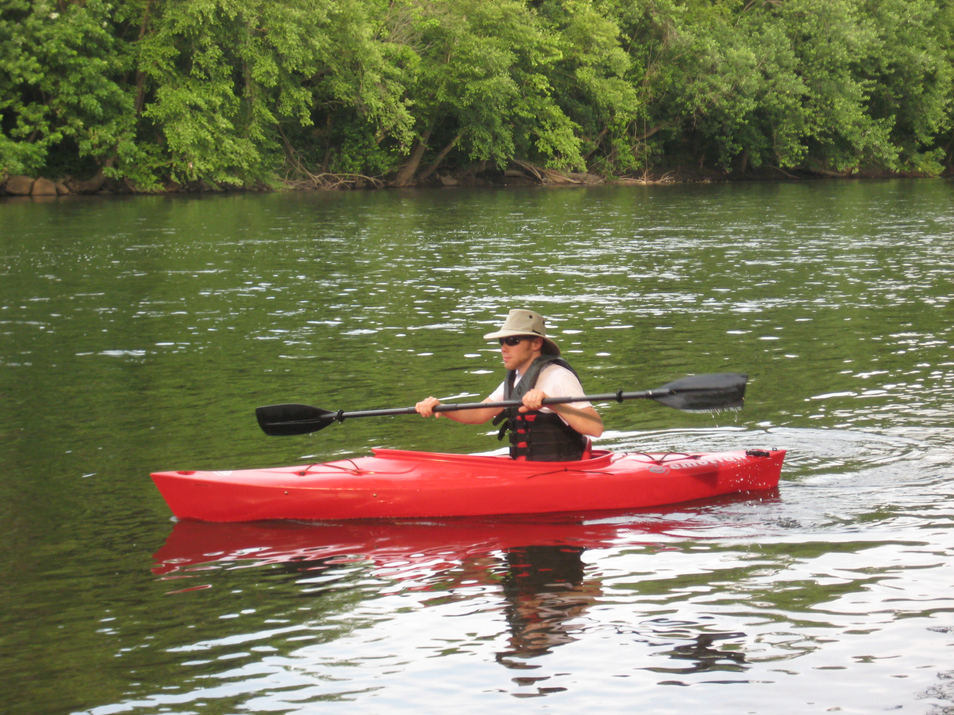
Before this trip, I wasn’t exactly sure how we’d do on the rapids with our recreational kayaks (an Emotion Glide, and a Perception Sport Sound 9.5). I’d done some research, and spoken to a few people with whitewater experience, and the consensus seemed to be that class-I rapids might be doable, class-IIIs would not be, and class-IIs were iffy. But there were also some people who scoffed at the very idea of taking recreational kayaks on rapids, no matter how gentle or rough.
Our previous experience included about 10 kayaking trips for me, and 5 for Kim, on rivers, lakes, and the ocean with small waves. So while we’d never done whitewater before, we had some kayaking experience under our belts. We also had life jackets, emergency whistles, cups for bailing water, and a flotation bag in my kayak, with flotation pillars in Kim’s (now upgraded to a flotation bag as well). We also had my iPhone (in an Aquapac which is quite awesome BTW), which I use for photos and navigation, and of course could be used to call for help. We didn’t end up needing any of those things, but the point is that we were reasonably prepared.
Based on all of that, I felt confident that we wouldn’t have any major trouble doing class-I rapids, particularly a small number of them on a relatively short stretch of a wide river, which is partly why I chose the Weissport canal loop for our first whitewater run. And it turned out to be just fine, quite easy, and super fun. It would be very difficult, if not impossible, to roll either of our kayaks, so unfortunately we won’t be heading up into the Lehigh Gorge and hitting the class-III rapids until we’re able to get some whitewater kayaks, but I definitely plan to do more of the many class-Is and perhaps some of the class-IIs in the sections south of the gorge.
Photos
As usual you can check out the photos (including the GPS map) from the trip.
Update: we went back a few weeks later and did a longer version of this run, kayaking from Jim Thorpe to Lehighton.
Previous kayak trip: Kayaking the Lock 60 Loop on the Schuylkill River.Next kayak trip: Kayaking the Hiwassee River in Tennessee.
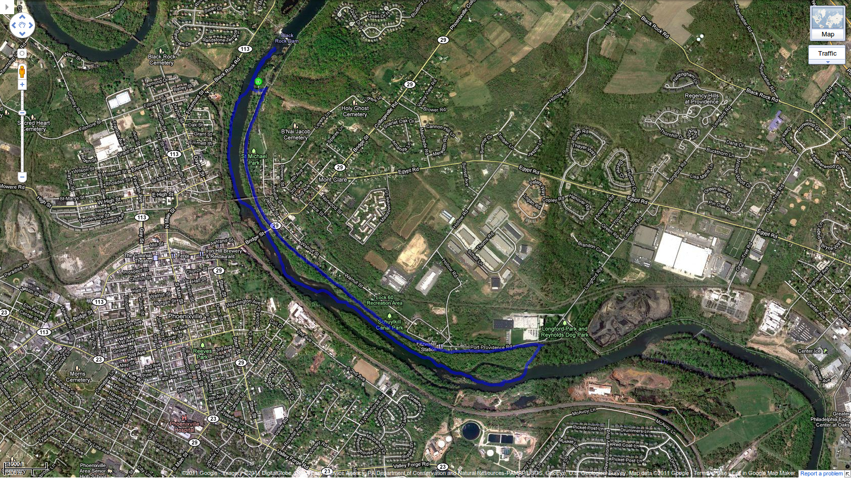
Kayaking the Lock 60 Loop on the Schuylkill River
Even though it was a disgusting 100 degrees on Saturday, and even though the river water was 90 degrees (no, really), Kim and I decided to paddle the lock 60 loop in Phoenixville/Mont Clare. Despite the heat, it was a nice trip.
We started at the parking lot just below Black Rock Dam, where we got into the river. The first thing we did was paddle upstream to the dam to check it out (though we couldn’t get all that close because it got really shallow, since the water level is a bit low: about 500 cfs at the Pottstown gage). Then we paddled downstream for about an hour, until we reached the portage point. This is easy to find because of the power lines: the portage trail from the river to the canal runs right under them. It’s a quick 5-minute walk where you can drag your kayak over the soft grass and dirt, then you hop in the canal and paddle "upstream" back to the parking lot (of course the water isn’t moving in the canal, but it’s upstream relative to the river’s flow).
The river at this section is pretty nice, with lots of small islands of really-soft-looking green plants, plus a bunch of ducks, geese, and cranes. And the canal is neat too, even though the water in it is of course somewhat stagnant. But it’s neat because it’s largely covered by a canopy of trees, and it goes right by a whole bunch of backyards, where people have set up small docks and fire rings and benches by the water. We spotted a few turtles too, though they were camera-shy and slid off their logs into the water before we could get any good shots of them.
Check out all the photos on Kim’s site, and here’s the GPS trail of our route:
Previous kayak trip: Schuylkill River Kayaking: Pottstown to Linfield.
Next kayak trip: Kayaking the Lehigh River: Weissport Canal Loop.
Love the Sun, Ditch the Sunburn
Mom and I were talking the other day about getting sunlight on your skin to make vitamin D, while not getting so much sun as to get a sunburn. Your body makes something like 10,000 IU of vitamin D from just 10 minutes of midday sun exposure -- assuming a decent amount of uncovered, non-sunblocked skin is exposed -- so it’s pretty easy to get enough D without getting burned. But then mom brought up an interesting question: why is it that, as kids, we were able to play outside in the sun all day with no sunblock and not get sunburned, whereas today, just an hour of sun will often cause a sunburn?
One theory is that ozone depletion, which has led to more ultraviolet light reaching Earth’s surface, is the cause of the increased sunburn incidence, but there doesn’t seem to be much solid evidence for that. It makes sense and I think it’s a factor, but probably not the whole story.
A few days after this conversation, Mark Sisson wrote a piece on natural sunburn prevention in his usual thorough and well-referenced style. It turns out that avoiding the sun, avoiding saturated fat, and loading up on omega-6 fats (e.g. vegetable oils) all increase the likelihood of getting a sunburn when you do get a rare bit of sun exposure. Of course those three things are all recommended by the US government, and by now I’m well beyond the point where I’m surprised that US government recommendations actually cause harm rather than helping.
I didn’t realize this until I read Mark’s article, but since I switched to a more primal/paleo diet earlier this year, I’ve been able to get a lot more sun exposure without getting sunburned. Last year, after hearing Steve Gibson’s comments on vitamin D and then deciding to go out and get some midday sun a few times per week, I could only get about 20 minutes before starting to burn, as I discovered one day when I tried to push it up to 30 minutes. But this year, although I again started at 20 minutes, I have since pushed it up to about 45 minutes and I’m not getting burned at all. The only difference is that this year, with my new way of eating, I’m consuming much less frankenfood like vegetable oil, and much more natural saturated fat.
Be sure to read Mark’s whole article on the topic for more natural ways to prevent sunburn, and don’t miss the comments, which are full of people reporting a complete lack of sunburn since having gone primal.
And if you’re worried about skin cancer, then you should seek the sun, not avoid it. Sun exposure protects against skin cancer, as long as it’s not overexposure.
Schuylkill River Kayaking: Pottstown to Linfield
My second kayak run on the Schuylkill was from Pottstown (technically, North Coventry) to Linfield. The trip was 9.5 miles and took just under 3 hours.
I really like this section of the river. Maybe it’s just because it was a nice sunny day, whereas my previous run (from Union Township to Pottstown) was on a cloudy day, but it seemed nicer and more rustic. You do pass the Limerick nuclear power plant, which is kind of neat, but after passing it, you’re right in the path of the noise from one of its buildings, which is a semi-loud fan-type noise that lasts for about a mile.
One highlight of this run is a very small section of rapids right near the take-out point. When I say small, I mean, it’s tiny; if it registers at all, it’s certainly no more than a class-I rapid. So it’s nothing that whitewater-lovers would get excited about, but it’s pretty fun in the middle of a nice peaceful trip down the Schuylkill.
A bit before the rapids, I saw some guys on the right bank swinging on a rope swing out over the water. I asked if they used it to launch into the water, and they said yeah, but only when the flow is up around 4000 cfs. On this day, it was about 1000, and only 2-3 feet deep in that area; I can’t imagine they see many days with the kind of discharge necessary to jump in.
I think one of the reasons I love the Schuylkill River so much is that it’s right there. I mean, it’s been right there my whole life, just waiting for me to discover it and get into it. I’m sorry it took me so long, but now I’m having a great time. It’s no Yampa River, but measuring Pennsylvania against Colorado is not exactly a fair fight :)
Thanks to the sunshine, I was able to take some pretty nice kayaking photos this time, so check them out!
Previous kayak trip: Kayaking on the Schuylkill River (Union Township to Pottstown).Next kayak trip: Kayaking the Lock 60 Loop on the Schuylkill River.
Tubing on the Schuylkill River
A couple of weeks ago, Mom, Maria, and I went tubing on the Schuylkill River near Birdsboro, and we had a great time. We went with the Schuylkill River Outdoors outfit, which is a business that opened up last year in Monocacy Station.
We drove to their location on the river, parked the car, and paid $15 each for the ~2-hour trip. They provided us each with a tube, put us onto a small bus, and drove us the 3 miles upriver to the put-in location. This is a small parking area right next to the river on what I presume is public land; it’s apparently used by fishermen and such. We hopped out of the bus and into the river, and we were on our way!
The water at the put-in spot was pretty slow-moving on this particular day, so there was some plant matter film on the surface, which wasn’t super-nice. But right after putting in, there’s a small channel on the left side of the river, which we paddled over to. This channel was really awesome: it was smaller, more fast-moving, and the water just seemed very clean and clear. It’s also almost entirely shaded, so it feels like a jungle in there.
The channel comes out just below the route 345 bridge, and then you’re back into the main part of the river, and the water is no longer filmy here. A few minutes after this, there’s a small island on the right, and just across from the tail end of this island, there’s a rope swing on the left riverbank. We discovered this a few minutes before we actually reached it, when, looking downriver, we noticed a kid go flying through the air and into the water! It looked totally awesome, so we paddled over and stopped so Maria and I could do a few swings into the river. It’s nice and deep at this spot -- maybe 8 feet or so -- so it’s the perfect place for a swing.
The rest of the trip was spent just lazily floating down the river, enjoying the sunshine and the outdoors. As I mentioned in my kayaking trip log, the Schuylkill River water is just so much cleaner than its reputation suggests. As long as it hasn’t rained much in the previous couple of days, the water is clear enough so that you can see the river bottom. And the only significant pollution we saw was tires on the bottom: probably a dozen or so during our trip. So considering how nice the river is, I’m continually surprised by how few people there are out on the water. It was a nice 95-degree day, but other than the group of maybe 10 teenagers at the ropeswing and on the island, we didn’t see anyone else the whole time.
Our 3-mile float lasted about 2 hours, and we ended at Schuylkill River Outdoors’ take-out point, where they’ve got a big "SRO" sign hanging in a tree, and one of their people standing in the river waiting to help you out of the water. SRO does a great job of getting you into and out of the water with minimal fuss: they provide the tubes and the ride upriver, then get out of the way so you can enjoy the water. At the end you hop in your car and leave. It’s a nice little gig they’ve got, and I hope they continue to do well and get more people back in touch with this beautiful river that’s right here in our backyard.
Here’s a map of the route we took:

Kayaking on the Schuylkill River
Last Saturday I kayaked in the Schuylkill River for the first time, and it was pretty awesome. Kim had bought me this sweet kayak for my birthday last winter, and I finally got a roof rack for it a couple weeks ago, so this was its maiden voyage.
I had only kayaked a few times before: on a lake near Ricketts Glen, on a river in the Bahamas, and on the ocean/bay in Cape Cod. Those times were all in rented kayaks and with other people; this time it was just me and the Schuylkill.
It was only in the past couple weeks, while researching places to kayak, that I discovered the Water Trails guides, including the Schuylkill Water Trail map. This is unlike every other standard/park/hiking map I’ve used, in that it shows all the bridges, dams, and potential hazards in the course of the river. And it also shows all the public landings that you can use to put in or take out of the river.
I put in at the Union Township landing, which I had never even heard of before seeing it on the Water Trail map. You access it via a tiny unnamed road off of route 724 that goes right between Monty’s Mulch and Tim’s Ugly Mug, and which I’d always assumed was part of one of those businesses, since there’s no street sign on it or anything. Only once you turn onto this tiny road and drive a bit do you come upon a sign declaring the existence of the landing. Update: sometime in late 2011 or early 2012, they put up a nice big sign for this landing, along with a new road, parking lot, and a couple of restrooms, so it’s now very easy to find.
Mom rode with me to the landing, so that she could then take my car back to the take-out point (Pottstown Riverfront Park) so it’d be there when I finished. She took some photos and videos of the launch, and she ended up waiting for me at the end to take some there too -- what a mom!
The kayaking trip was 8 miles long, and it lasted 2 hours. As I note in one of the videos, I was moving at about 4-6 miles per hour when paddling, and about 2 mph when I just sat back and let the river do the work.
During the trip, I was struck by how peaceful the river is, and also how empty it was. In the whole 8 miles, I saw only 6 other groups of people: 4 dudes in an inflatable tube on a Schuylkill River Outdoors trip; a guy in the river fly-fishing; a man and his small kids on one of the landings; and 3 rowboats with motors, each containing two fishermen. I mean, I’m kinda shocked that I’ve never spent any time in the river before (other than a few water-skiing/kneeboarding trips with my neighbors back in the mid-90s), and it just seems crazy to me that in the middle of a nice hot Saturday, so few people were out there enjoying the water.
I was also impressed by how clean the Schuylkill is, at least compared to what I think is the common view of it being a dirty river. The water itself was nice and clear (of course I checked the Philly RiverCast before getting in), and I only saw maybe half a dozen pieces of litter in the entire trip. There were however quite few tires on the bottom: I must’ve seen a dozen or more in the course of the 8 miles I paddled. If I had one of those powered rowboats, I might try to pick up a tire each time I went out on the water, to eventually get rid of all of them.
All in all it was a great trip, and I can’t wait to do it again. Don’t forget to check out the photos and videos that mom and I took before/during/after the trip.
Next kayak trip: Schuylkill River Kayaking from Pottstown to Linfield.
Why You Can't Get Sunburn Near Sunrise And Sunset
[For people finding this page by searching for things like "how late can you get sunburn", the short answer is that in the continental US, it’s virtually impossible to get a sunburn before 10 AM or after 4 PM, except in subtropical places like Florida.]
When the weather starts getting nice, I start thinking about the sun and UV rays and how to avoid sunburn. I always try to plan my outdoor activities (biking, tubing, etc) to avoid the worst part of the day in terms of sunlight, which is when the sun is directly overhead -- around 1 PM in North America. Sun exposure is crucial for proper health, but only if it’s time-limited so that it doesn’t give you a sunburn.
You’ve probably noticed that, while you can get a tan/sunburn in half an hour or so around midday, it’s pretty much impossible to get any tan -- let alone sunburn -- within an hour or two of sunrise and sunset. When I got my iPhone 4 last June, I stood in line at the Lehigh Valley Apple store from about 4:30 PM to 7 PM. It was a hot, sunny day; the Apple employees were giving out bottled water, and the line was in direct sunlight the whole time. Despite this, I didn’t get a bit of tan.
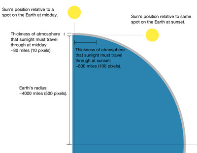
The reason is because sunlight has to travel through the Earth’s atmosphere before it reaches us on the surface, and the atmosphere blocks some of the UV light. When the sun is directly overhead, its light has to travel through a certain amount of atmosphere, but when the sun is at more of an angle (further from midday), the amount of atmosphere that sunlight must travel through is greater.
But how much greater? I wanted to figure this out, and a little Googling didn’t turn up anything. So I thought about how to model it, which is pretty simple: you just need to draw a big circle with a thin band surrounding it, then compare the thickness of the band at different angles. So that’s what I did:

The Earth’s radius is about 4000 miles, and the atmosphere (depending on how you want to define it) is, say, 80 miles thick. The precise thickness doesn’t matter for our purposes here, though; all that matters is the ratio between the smallest thickness (the midday atmosphere) and the greatest thickness (the sunrise/sunset atmosphere).
By drawing two exact circles that are concentric, and using 1 pixel to represent 8 miles, it’s easy to "calculate" the sunrise/sunset thickness: you just need to count/measure the pixels. There are 100 of them, compared to 10 pixels for the midday thickness, so the UV radiation must pass through ten times as much atmosphere at sunrise/sunset as it does at midday. That explains why virtually none of that UV light passes through around sunrise and sunset: the atmosphere is far too thick for the UV to penetrate.
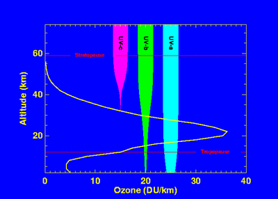
Update: here’s a related graph from NASA (via Wikipedia) showing how much of each UV fraction is blocked by the atmosphere (mainly the ozone layer):

It shows that the atmosphere blocks all UVC, and most UVB, but only a small amount of UVA.
Morning Dew
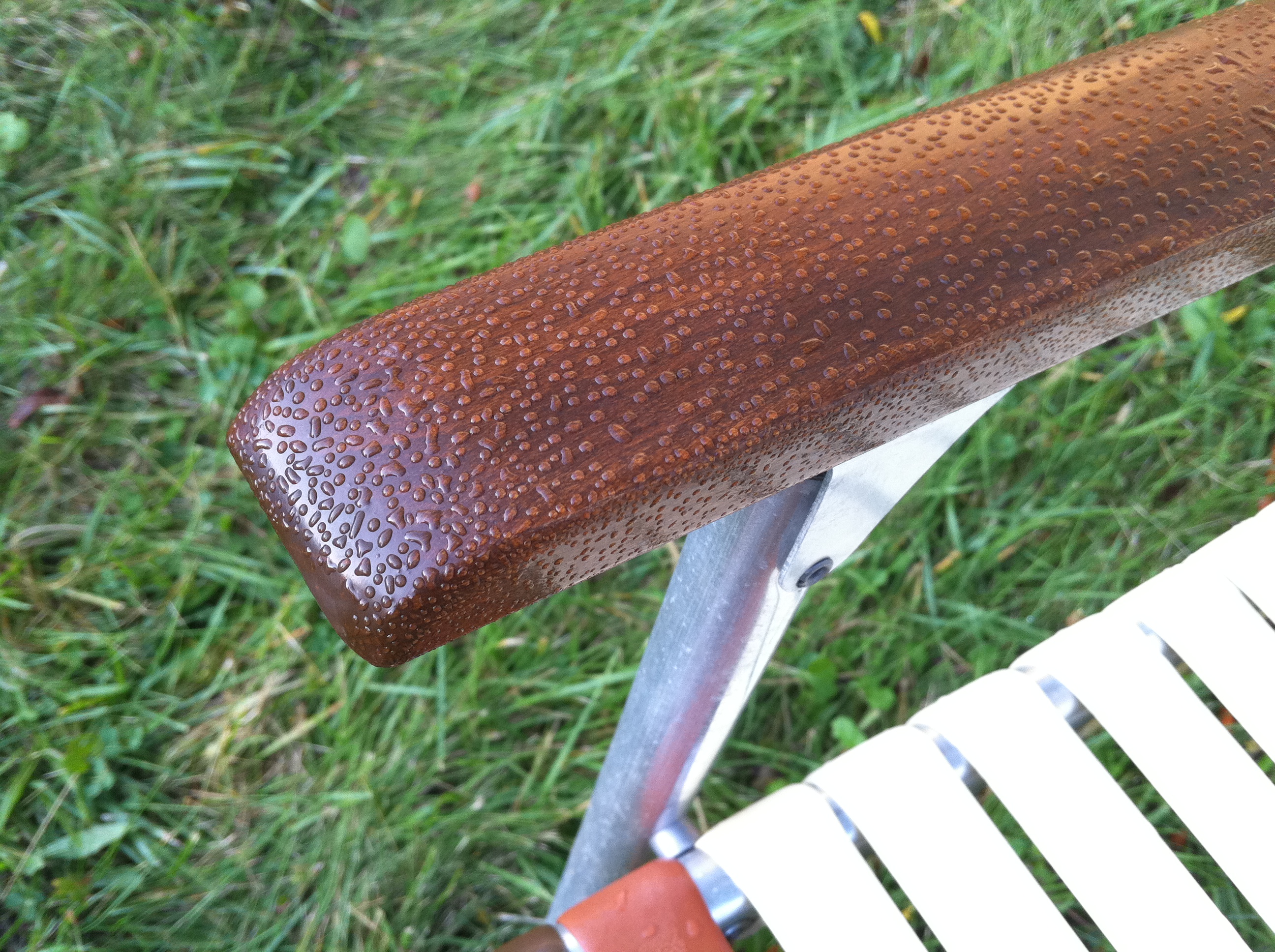
It’s not a particularly amazing composition, I know, but I do really like the dew pattern; and upon noticing it, I didn’t even think twice about pulling out my iPhone 4 and shooting it: by now I’m pretty confident in its ability to do a good job with the detail in macro-ish shots like this. Be sure to click the image to see it at 100%.
The iPhone 4 camera is really quite good, especially in comparison to the one in the 3G, which was basically worthless for anything other than well-lit non-macro close-range portraits. I mean, it was "decent for a cell phone camera", but you wouldn’t want to use it for anything too important. Not so with the iPhone 4.
Sunset Sky
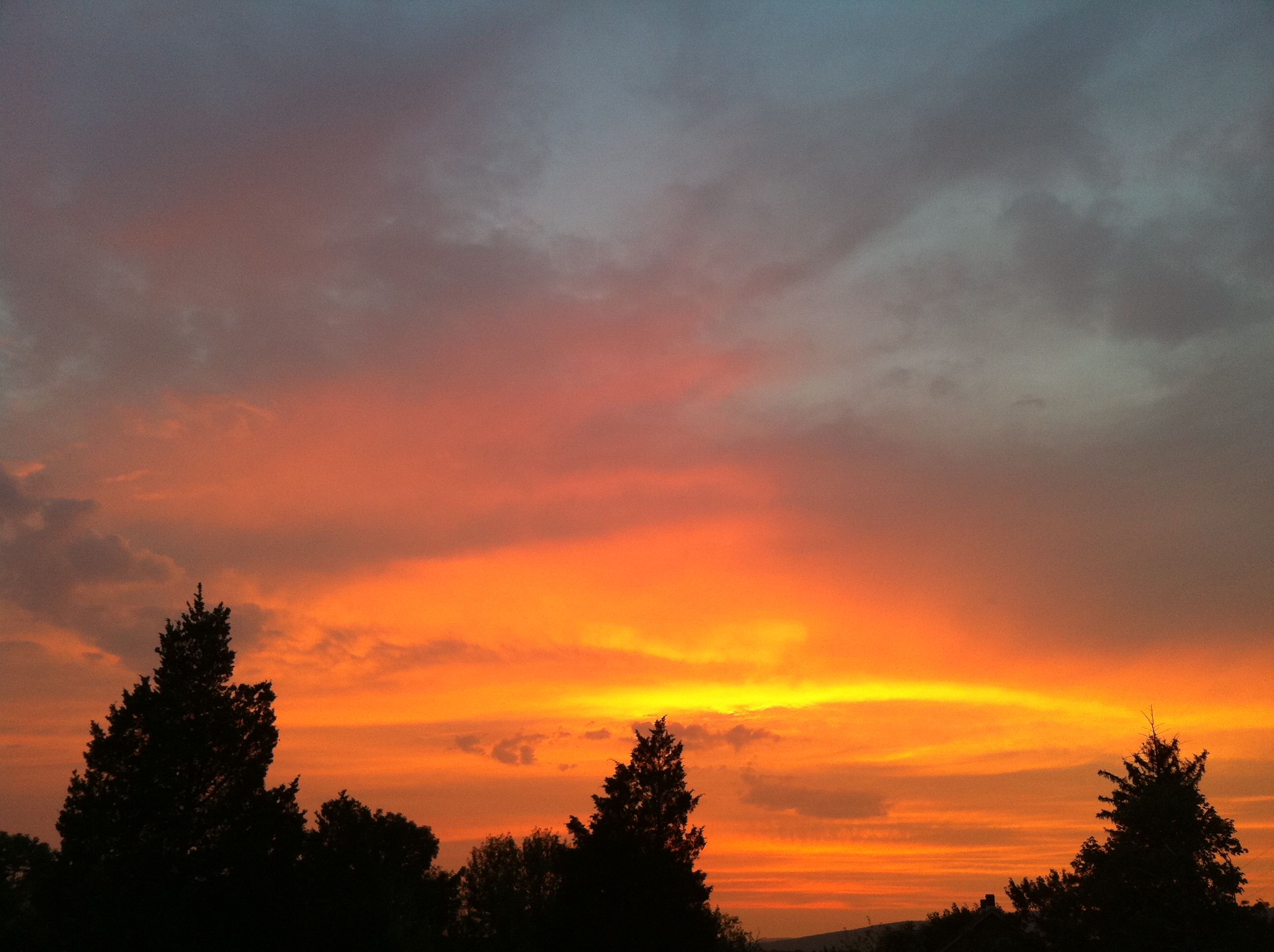
I took these photos with the iPhone 4, whose camera is far better than that in the 3G. It’s probably about as good, in terms of image quality, as my Sony DSC-S85, which is 10 years old now.
New Layout
I really love the new header image; the colors are wonderful. Do you know where this shot was taken? Also, when do we (and our kayaks) leave? : ) Can’t wait.
The Best Mountain Bike Trails in Pennsylvania...
...are not actually in PA: they’re right across the border in Delaware. I’m talking about Middle Run Park and White Clay Creek. I biked these trails with Rolly yesterday, and I was amazed by their awesomeness. I haven’t had this much fun biking in a long time. In fact I’d say these are the best trails I’ve ever ridden.
We started at the parking lot for Middle Run Valley Natural Area, off Possum Hollow Road. From there the trails go into the woods and then loop all over the place. We did 11.4 miles (in 3 hours total with 90 minutes riding time) and I’m sure we didn’t even bike half of the total trail length. We were using a copy of this map, but if you’ve got a GPS-enabled smartphone and a couple of hours to ride, you could just note the location of the parking lot, then head into the woods and ride. The trails are mostly all loops and you could pretty easily find your way back.
What’s so great about Middle Run Park is that the trails are mostly smooth dirt singletrack, without any huge hills. There are lots of hills, but they’re mostly small, so that you’re not killing yourself grinding up any mountains. Instead you’re flying up and down these small fast hills, then flying through a meadow, then flying over a creek, then flying through a creek... it’s MTB heaven. The place was apparently designed by bikers specifically for bikers, and it shows. They’ve done a great job.
There’s a nice "Skills Trail" that has log rides, wooden plank bridges, and even teeter-totters. There are some pretty big drops to be dropped too. And throughout the park there are quite a few plank bridges, some over creeks and some just for fun, some with railings and some without. It’s not exactly Kranked, but in some spots it kinda feels like it.
The terrain is pretty varied too, even in the relatively small area that we covered. There’s some plain old forests, some beautiful meadows, and we even hit a pine forest, which smelled wonderful. One of my favorite parts was a tight, windy, small-hilly section that was cut into the side of a larger hill; it had a decent drop off the one side and really just felt like a jungle to me.
Perhaps the best thing about Middle Run, for me, is the lack of rocks. I’m used to riding in places like French Creek, Wissahickon/Fairmount, and a few places near State College, all of which are essentially giant rock gardens. You ride it if it’s all you’ve got, but I would never ride those places again if I had something like Middle Run nearby. Alas, Middle Run is about 75 minutes away, but even at that, I intend to make many trips to there in the future. The difference between riding the local pure-rock trails and riding Middle Run is like night and day.
Beautiful Pennsylvania Photography
It looks like Kathleen Connally over at A Walk Through Durham Township has just opened up a little print shop where you can get your very own wall-hangin’ copies of some of her amazing photographs.
Durham Township is just a couple counties away from here, and Kathleen has been turning out beautiful shots of our little corner of the country for years now. So if you want to put some artwork on your wall and support a local artist at the same time, then head on over.
Winter Weather
Toxic Waters
Great reporting by The New York Times on the appalling state of enforcement (i.e., virtually none) of water quality and safety regulations, at both the state and federal levels, throughout the US:
Quoting The New York Times:
In the last five years alone, chemical factories, manufacturing plants and other workplaces have violated water pollution laws more than half a million times. The violations range from failing to report emissions to dumping toxins at concentrations regulators say might contribute to cancer, birth defects and other illnesses.
However, the vast majority of those polluters have escaped punishment. State officials have repeatedly ignored obvious illegal dumping, and the Environmental Protection Agency, which can prosecute polluters when states fail to act, has often declined to intervene. [...]
Some violations are relatively minor. But about 60 percent of the polluters were deemed in "significant noncompliance" -- meaning their violations were the most serious kind, like dumping cancer-causing chemicals or failing to measure or report when they pollute.
Finally, the Times’s research shows that fewer than 3 percent of Clean Water Act violations resulted in fines or other significant punishments...
"I met our inspector at the spill site, and we had this really awkward conversation," [DEP regulator] Crum recalled. "I said we should shut down the mine until everything was cleaned up. The inspector agreed, but he said if he issued that order, he was scared of getting demoted or transferred to the middle of nowhere. Everyone was terrified of doing their job."
Mr. Crum temporarily shut the mine.
In the next two years, he shut many polluting mines until they changed their ways. His tough approach raised his profile around the state [of West Virginia]. [...]
In 2003, a new director, Stephanie Timmermeyer, was nominated to run the Department of Environmental Protection. One of West Virginia’s most powerful state lawmakers, Eustace Frederick, said she would be confirmed, but only if she agreed to fire Mr. Crum, according to several people who said they witnessed the conversation.
She was given the job and soon summoned Mr. Crum to her office. He was dismissed...
The 7-page report focuses on some specific West Virginia problems but deals largely with nationwide issues. They’ve also compiled a national database of pollution-discharge compliance and violations.
Cape Cod: Great Beaches, Bad Restaurants
Last week, we took a fun little vacation to Cape Cod. We left Sunday and returned Thursday, but because the drive takes a whole day -- it’s nominally ~7 hours, but longer if you include a few bathroom breaks and a meal stop -- we really only spent 3 days there.
Our plan was to camp, because we like that and we’re used to camping at the Jersey shore. But the campground doesn’t let you check in after 9 PM, so we had to stay in a hotel the first night. The brand-name hotels were all around $200 per night, so I tried to find something cheaper, and found Cape Point Hotel for $135. It turned out to be pretty terrible: the hallway to our room and our room itself had a strange gross smell; the air conditioner continually turned itself off and on despite being set to stay on; the handle on the toilet fell off when you touched it; and, as we checked out, the woman at the desk didn’t even ask how our stay was. I assume she already knew.
On Cape Cod you have the bay on the north shore, the sound on the south shore, the ocean on the east shore, and then you have lots of huge inland ponds. On the first day we checked into the campground around 1 PM, set up camp, and then walked the ~1 mile to the bay. But it was low tide when we arrived there at around 3 PM, and low tide on Cape Cod Bay means you need to walk about three-quarters of a mile to get to water that’s more than ankle-deep. It was neat to see, especially the dozen or so boats that were anchored and sitting on dry land due to the low tide, and the water was quite warm, probably 75F or slightly warmer. And it was nice and uncrowded, with perhaps 100 people spread across the one square mile or so of beach and bay.
But I really wanted to get into some real ocean water that was cool and deep enough to swim in. On the second day, we mapped a bike ride across the peninsula to Nantucket Sound. Starting at our campground in Brewster, it was a short 1.5 mile ride on route 137 to Underpass Road, where we picked up a bike path that goes almost right across most of the peninsula. We got off the path at Lothrop Ave and took that to Earle Road, which led us right to Earle Road Beach. It’s a small beach, probably not even a football field long, but we arrived around 10 AM and there were only 3 or 4 other groups there. It had decent waves despite technically being the sound and not the ocean, and the water temperature was perfect, probably about 73-75F. As a longtime Jersey shore beachgoer, I loved how soft and shell-free the sand was, and how clean the water was. After an hour or so, we biked back across the cape to our campsite. The ride was 8.5 miles each way, which took us about 50 minutes, so it was a good ride -- and it was neat to pass several of the huge ponds along the way. We’ll definitely have to swim in some of those next time.
Later in the day we drove up the cape, in search of sand dunes and a nice ocean-side beach, which we eventually found (thanks to Brian’s navigational help) in Wellfleet. At this particular beach the parking area is about 75 feet above sea level, so you have to take one of two steep diagonal trails down the face of the sand dune to get to the beach. It was late in the day when we arrived, so we didn’t swim, but I did walk into the water up to my shins, and it was cold. The water was nice and turquois, though, as you can see in the satellite view, so I think we’ll probably make a point to swim here on our next trip.

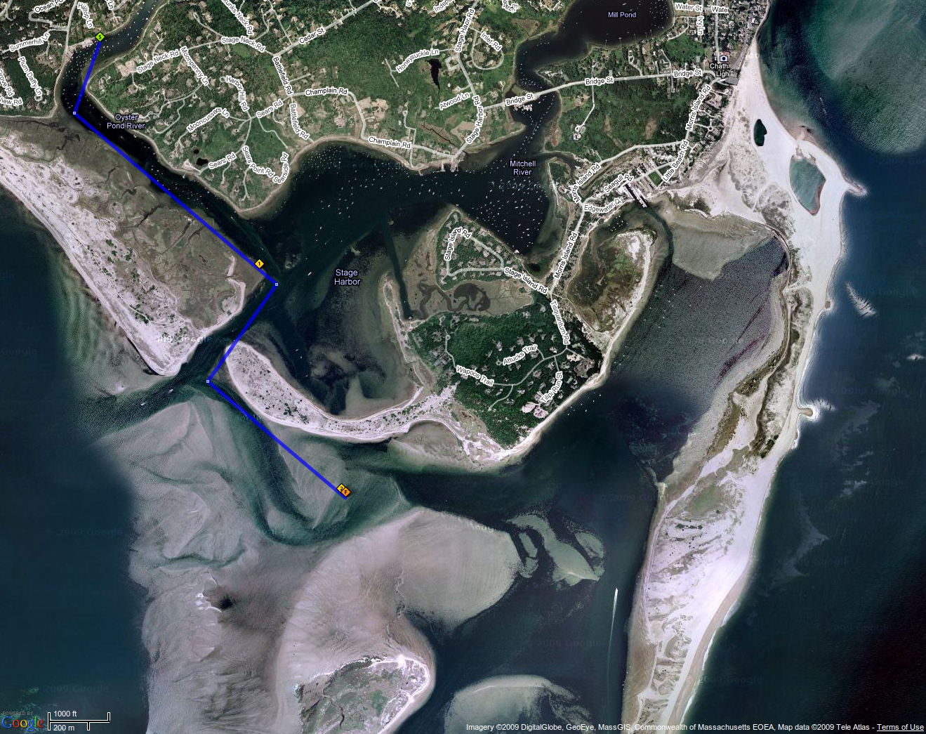
On our third and final day, we rented kayaks from The Chatham Kayak Company. The fancy name contrasts with the extremely informal (in a good way) nature of the operation: you drive to the end of Barn Hill Road, make a hard left just before the parking lot, and Anne or John emerges from a shack to take your information and put you into a kayak. They’re right on the water of Oyster Pond River, so you’re into the water and ready to go pretty quickly. We headed towards Stage Harbor, then went out the small channel into the sound (or technically, I guess it’s Sequetucket Harbor at that location). We went about 2 miles, not quite making it to the ocean, but we did get into some waves, and in fact I capsized my kayak on one of them. This turned out to be a good thing, because I lost our only water bottle when I flipped, which meant that we had to head back; and we ended up with pretty decent sunburn after the ~2.5 hour trip as it was, so we’d’ve been in bad shape if we stayed out much longer. Here’s the route we took:
The kayak trip was the highlight of the vacation, though. We’ve kayaked a few times before, but never on open water like that. It was really neat to be able to just go wherever you wanted, and to stop at beaches which were inaccessible except by boat and therefore totally devoid of people. Not having kayaked much before, I forgot that there’s actually a lot of room in the boat for stuff like water bottles, extra sunblock, etc; had I realized that, I would have brought a backpack with enough supplies to turn it into a half day’s adventure.
The Restaurants
The nice water, beaches, and bike trails on Cape Cod are unfortunately beset by countless restaurants -- bad restaurants -- which were the downside of an otherwise awesome trip.
On the first morning, we ate breakfast at Hearth ’n Kettle. This place looks promising: nice on the outside and country-style on the inside, like a less fake version of Cracker Barrel or Bob Evans. But once seated, we had a longish wait before our waitress noticed us and took our orders. My omelette was made of something other than natural eggs; I’ve never knowingly eaten "egg beaters" or anything like that, but that’s what I thought of -- it was slightly rubbery, perfectly smooth on top, and just unnatural. The "home fries" were new potatoes that were just halved and deep fried, rather than cut up and pan-fried. But that stuff is minor compared to what happened when the waitress brought out the tray of food for the table across from us. She accidentally knocked a piece of toast off a plate and onto the surface of the tray, then grabbed it with her bare hand, fumbled it a few times and generally just smooshed it around on the dirty tray surface, and then placed it back onto the plate. This happened right next to us and away from the table where the food was going, so they probably didn’t see it; Kim and I just watched in horror.
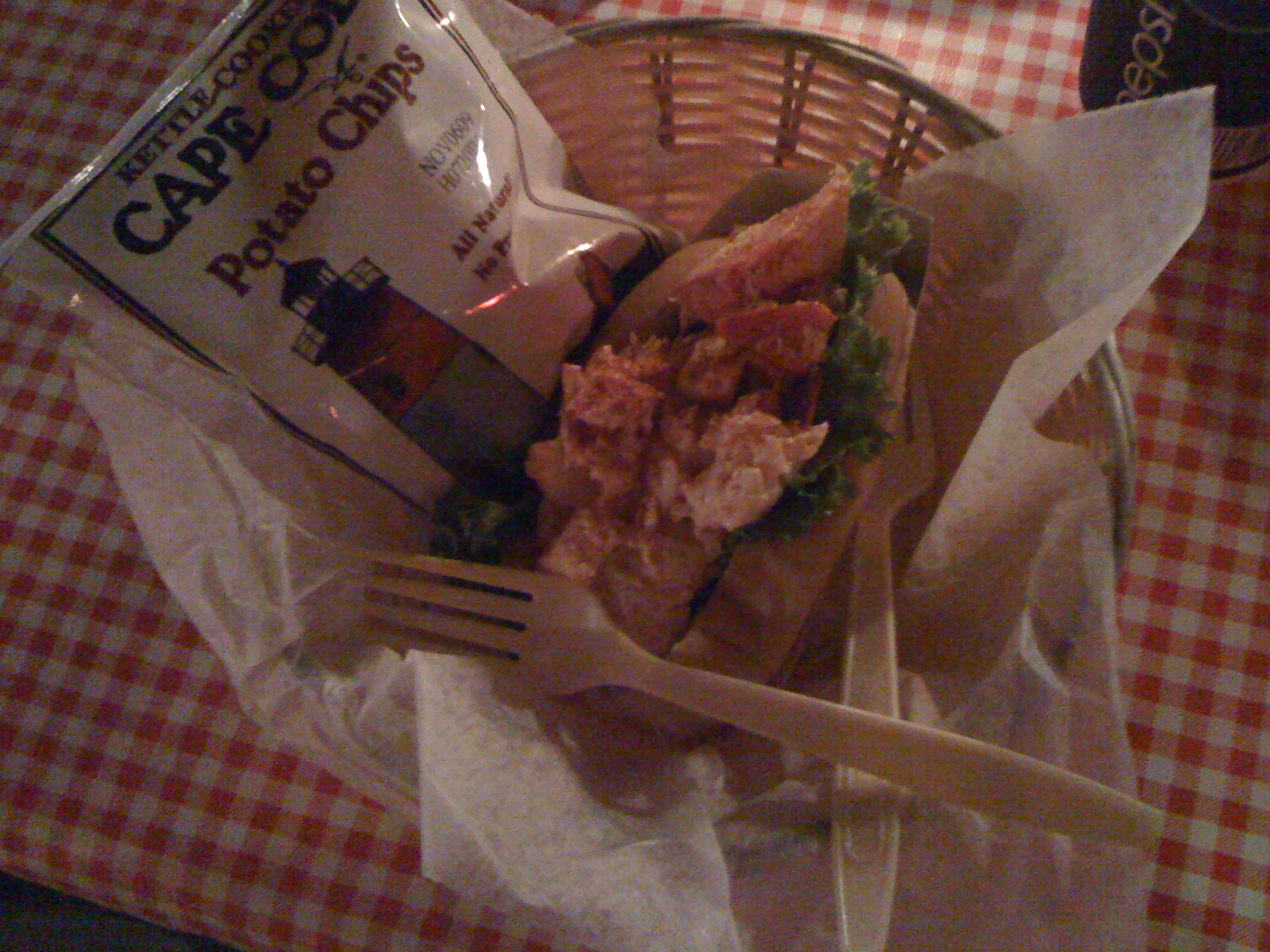
Before the trip, I spent a fair bit of time researching restaurants on Fodor’s and TripAdvisor. The #1 Cape Cod restaurant on TripAdvisor is Moby Dick’s, and after reading the reviews, it seemed like a safe bet. When we arrived there was a long line with an hour-long wait, but it ended up being only a half an hour due to some people bailing out early. We were seated in what appears to be the only section in the whole place, which is basically a screened-in deck with powerful overhead fans blowing right on you and your food. (I do recall being asked whether we wanted to choose where we sit, or take the first available table; this was after our long wait to get in, so we opted for first available, but I assume that perhaps this means there actually is another section, which is hopefully more indoors and nicer.) I had never had a lobster roll before, and since they’re all the hype on Cape Cod, and since I love lobster, I decided to try one. It wasn’t bad, but was certainly nothing special; and I gather that they’re supposed to be cold, but I guess I just don’t care for cold lobster. The bread/roll was just barely toasted, and it was overall pretty small, I’d guess 8-10 ounces. The presentation certainly left something to be desired (see photo below). So on the whole, Moby Dick’s wasn’t terrible, but was not especially good either. I doubt we’ll go back.
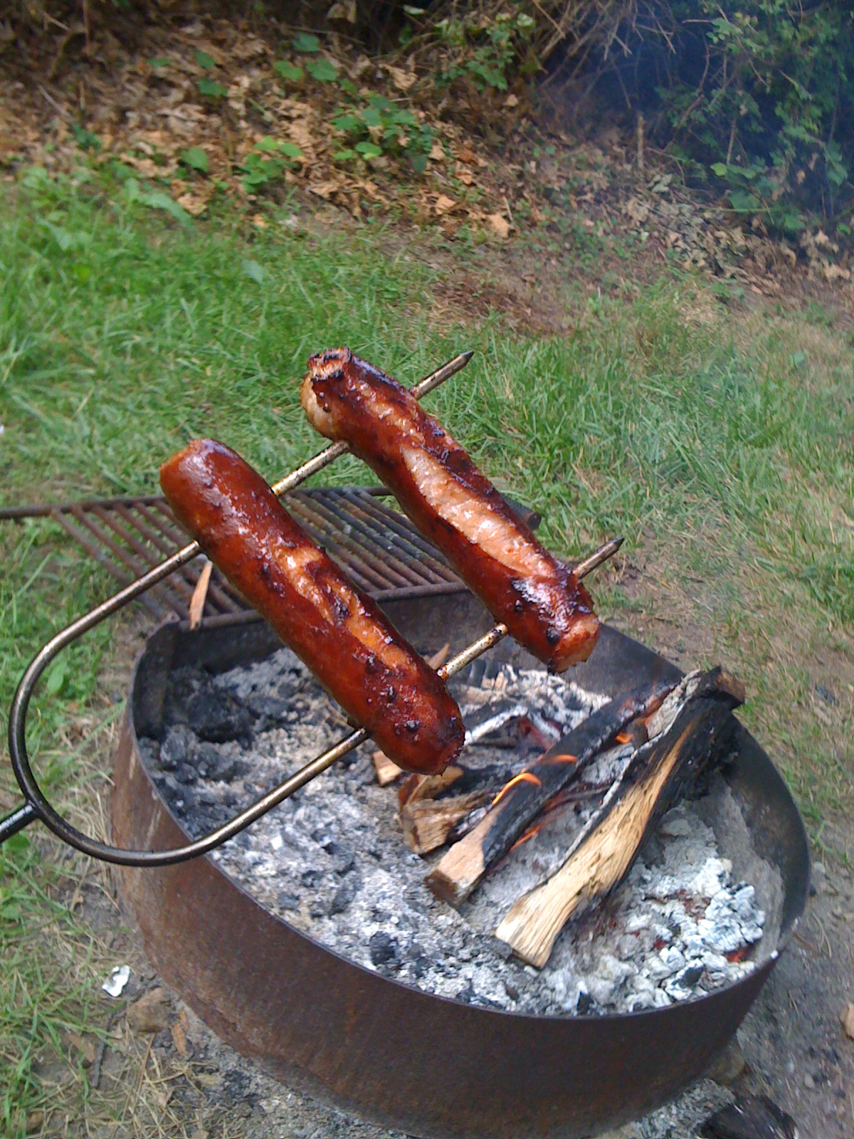
In the mornings, I made a campfire and roasted up some bratwurst and sausage; these were by far the best meals I had on Cape Cod:
Our next meal out was at Carmine’s in Chatham. This is a pizza shop, and I thought the pizza was decent, though nowhere near as good as Mack and Manco or Grotto. Kim wasn’t crazy about it. However, considering that I am apparently a pizza snob, the fact that I think Carmine’s is OK might actually be a decent compliment for them. I wouldn’t mind getting pizza here again. The one downside was that there’s no bathroom, which means nowhere to wash your hands; you have to walk out the back of the building, around a corner past another building, and across a parking lot to get to public restrooms (they were nice restrooms though).
Another restaurant that had good reviews was The Paddock, so we went there on our second night. This place looks nice and fancy; it doesn’t have a dress code, but they do the full table sets with proper silverware and plate layouts, wine glasses, etc. They served pre-meal bread with dipping oil, which I love, and this particular oil also had some kind of tomato-based herb mixture under it, and it was amazing. My salad was also quite good, and my meal -- peppercorn-encrusted swordfish -- was really good too. However, it was more like peppercorn-conquered swordfish -- not a bad thing in my book -- which made it really spicy, and I finished my tiny-wine-glass portion of Coke in no time. I couldn’t continue to eat it without more beverage; and Kim was also at an impasse with her meal at this point. But after delivering our meals, our waitress abandoned us for at least 15 minutes (Kim thinks it was even longer), during which time we watched her yakking it up with various other patrons across the room. When she finally returned, and found us sitting there staring at our plates, she asked something like, "Oh, are you not enjoying your meals?" I said no, we’re waiting for refills on our drinks, to which she replied "Oh, we don’t do refills here; but maybe I could bring you new ones?" So she chose to interpret my request as a wish to have those specific glasses refilled, rather than the obvious interpretation which is we need more to drink. She made it seem like there was something wrong with me, as if additional drink is an unusual request, and she never apologized for disappearing for most of our meal. To top it all off, she charged us for the extra drinks, at $4.50 each -- for soda!
Our final Cape Cod restaurant stop was at JT’s Seafood Restaurant. The sign by the road for this place is fancy, making it seem like this will be an at least somewhat fancy restaurant. But when you get inside, it’s set up like a cafeteria. There’s a big board on the wall with those slidey plastic letters; this is the menu. You order and pay for your food, then go sit down and wait for them to bring it to you. The place seemed decently clean, but the decor was just... ridiculous. The dining room is half tables, half booths, with the booths on a raised level; the walls were white and mostly bare; the music was... I don’t remember except that it was bad. I can’t quite put my finger on what was wrong with the layout and decor, but it just didn’t make sense; things didn’t go together, and it kind of seems like it was someone’s house that they just put some booths and tables into. All of that is subjective so maybe it’s not entirely fair, but Kim and I both just got a weird vibe from the setup. The real problem, though, was that the lobster I ordered came on a paper plate. With a piece of corn-on-the-cob and a biscuit on top of the lobster. And plastic silverware. You have to take everything except the lobster off the plate to start working on the lobster, and of course lobster is a big mess with tons of water coming out of it, which quickly turned the paper plate into a disaster. And the lobster was $20, which isn’t hugely expensive, but I had thought that lobster was supposed to be so cheap in New England.
IHOP, Save Us!
Fortunately, Cape Cod does have a bunch of good chain restaurants. On our way out of town on Thursday morning, we got breakfast at IHOP, and it was wonderful. And we had previously gotten dinner at Outback Steakhouse on the way to Cape Cod, about halfway into the trip; I got tilapia covered in mushrooms and crab meat, which was wonderful, and Kim got ribs -- Outback was great, as it consistently is. And on the cape we did see an Olive Garden, a Pizzeria Uno, and a Friday’s, all of which we like and are usually very good. We should have cut our losses after the first or second disappointing local restaurant, but I wanted to believe we could find something good. But at least we know for next time: pack more campfire food, and eat out at the known-good restaurants.
While researching restaurants before the trip, I did come across an article titled "On Cape Cod, Desperately Seeking Seafood" in the Washington Post; I guess I just didn’t want to believe it:
Quoting The Washington Post:
I presumed the crowds happily standing in line to order were there for the food.
I presumed wrong. The fried clams were indistinguishable from the onion rings, which tasted remarkably like the fried shrimp. After a few bites I felt as if I had rubbed a bowl of grease onto my face.
"You don’t come to the Cape to eat," my husband explained, polishing off his french fries, or were they clam strips? [...]
You have to seek [good food] out, to distinguish by trial and error the few spots that are good from the many that are adequate or worse.
And that’s the problem: Cape Cod is basically wall-to-wall restaurants, and -- in that author’s experience, and ours -- few of those restaurants are good.
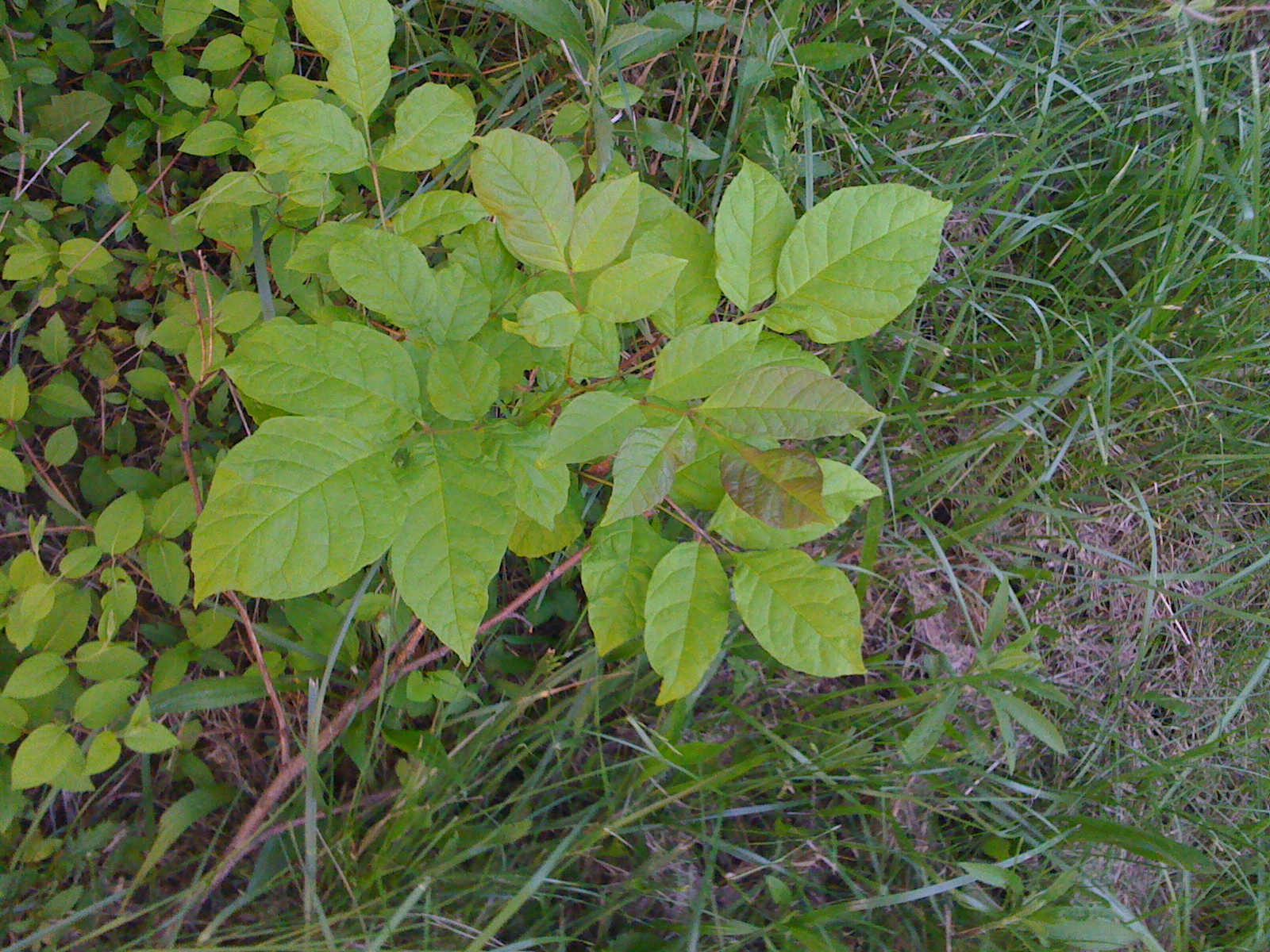
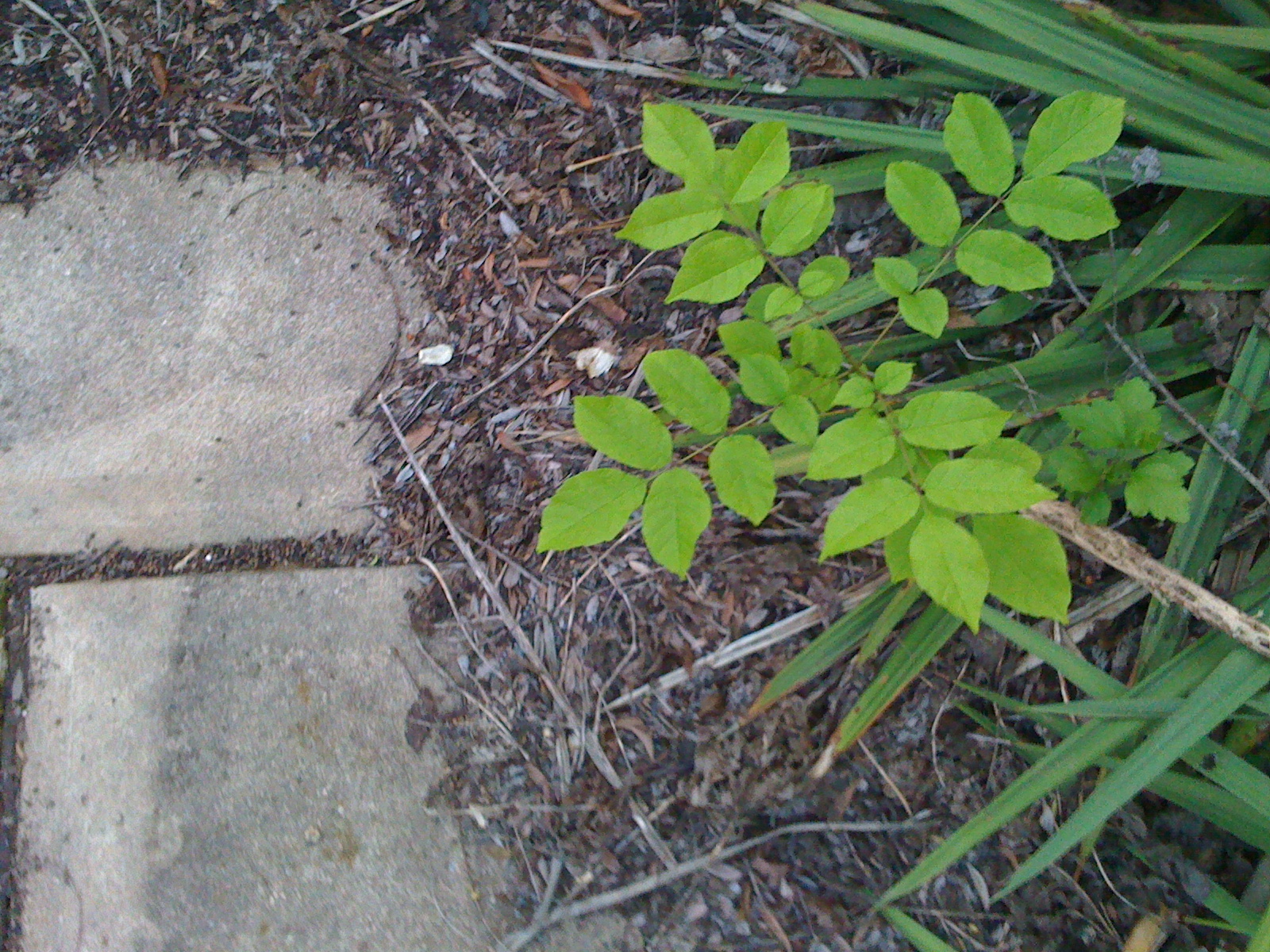
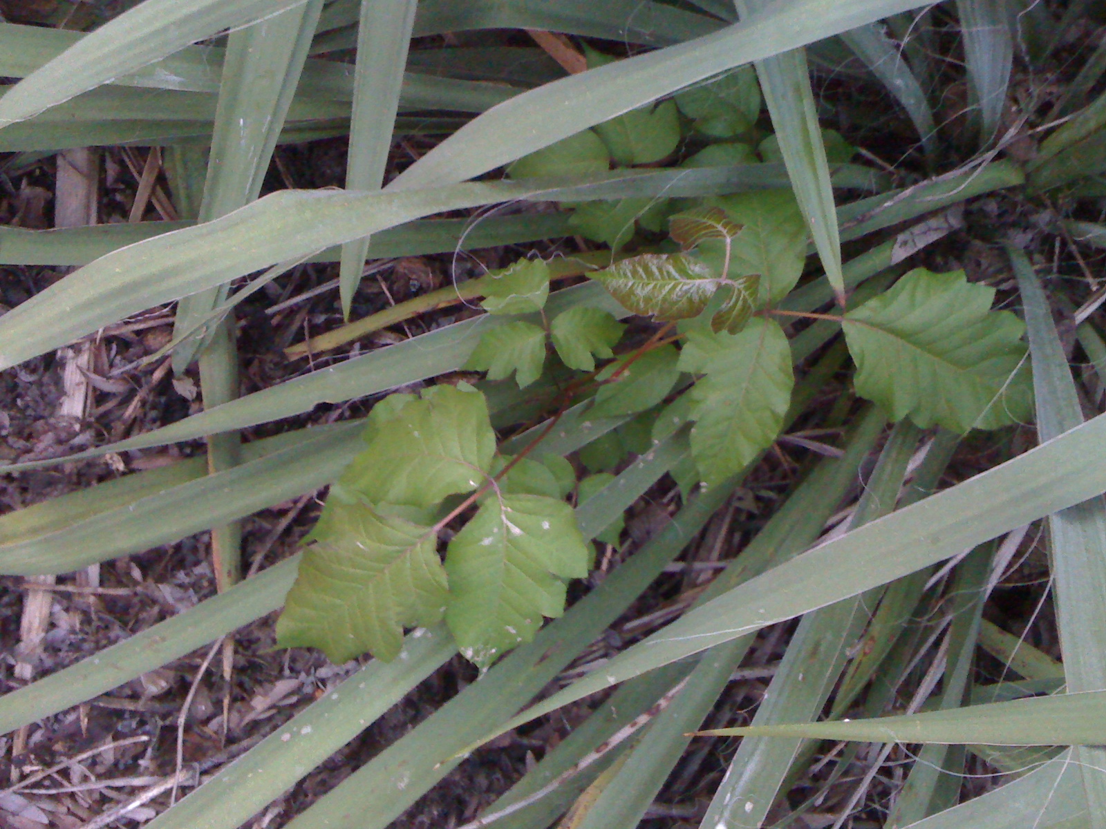
Poison Ivy
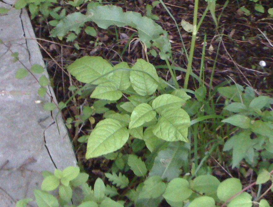
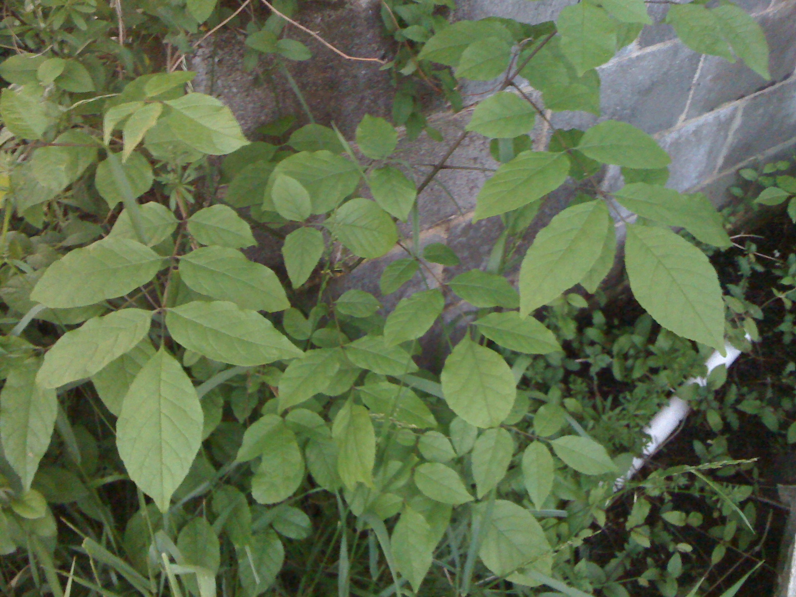
I never in my life got poison ivy until last year when we moved here; this place is apparently crawling with the satanic plant. But never having worried about it before, I’m not very good at identifying it, and now I’m paranoid, so I think that any plant with leaves in triplets is poison.
Some of these look like they’re definitely poison; others I’m not sure. What do you think?
1:

2:
3:
4:
5:
6:
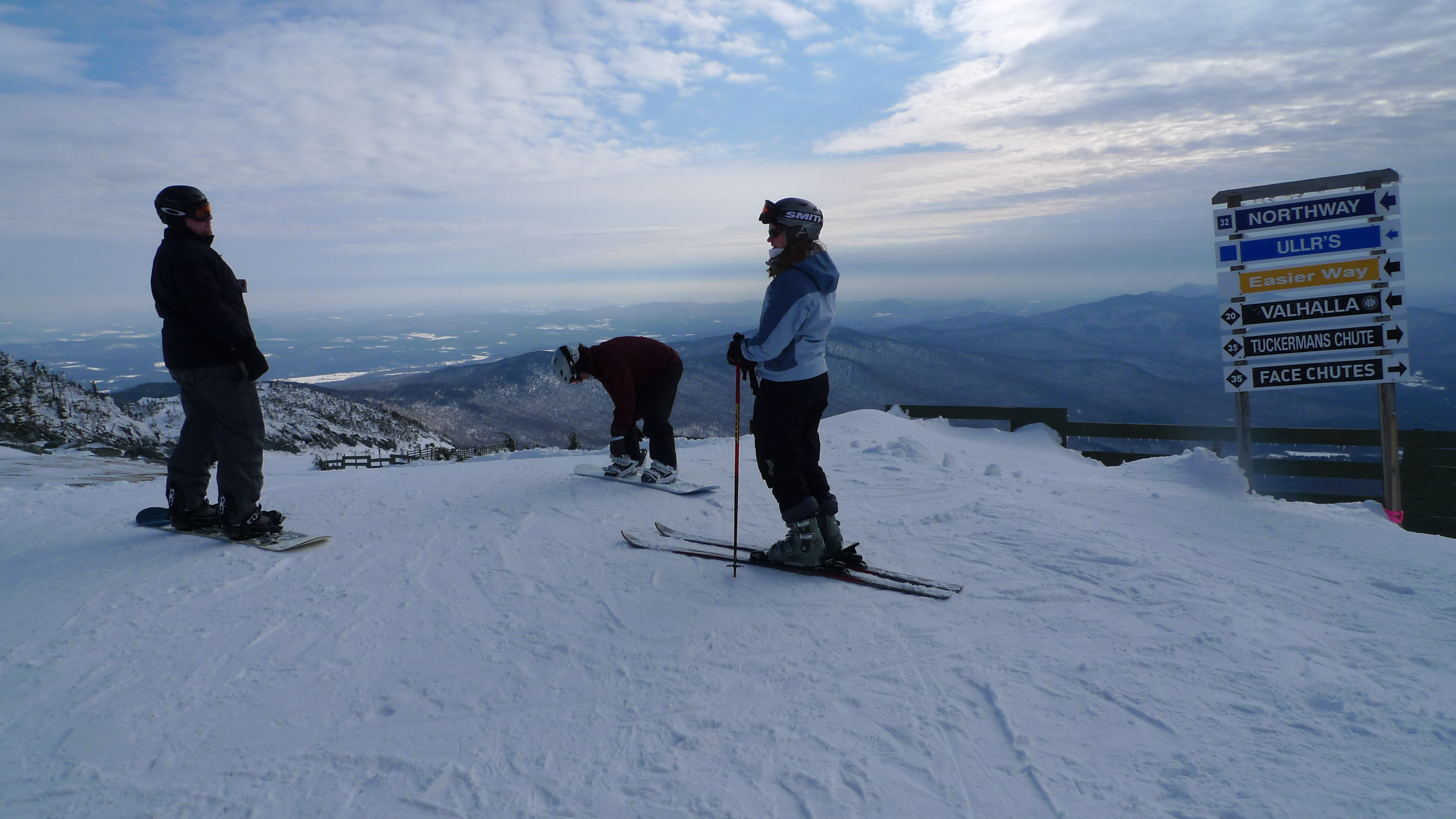
Idiot's Guide to Skiing
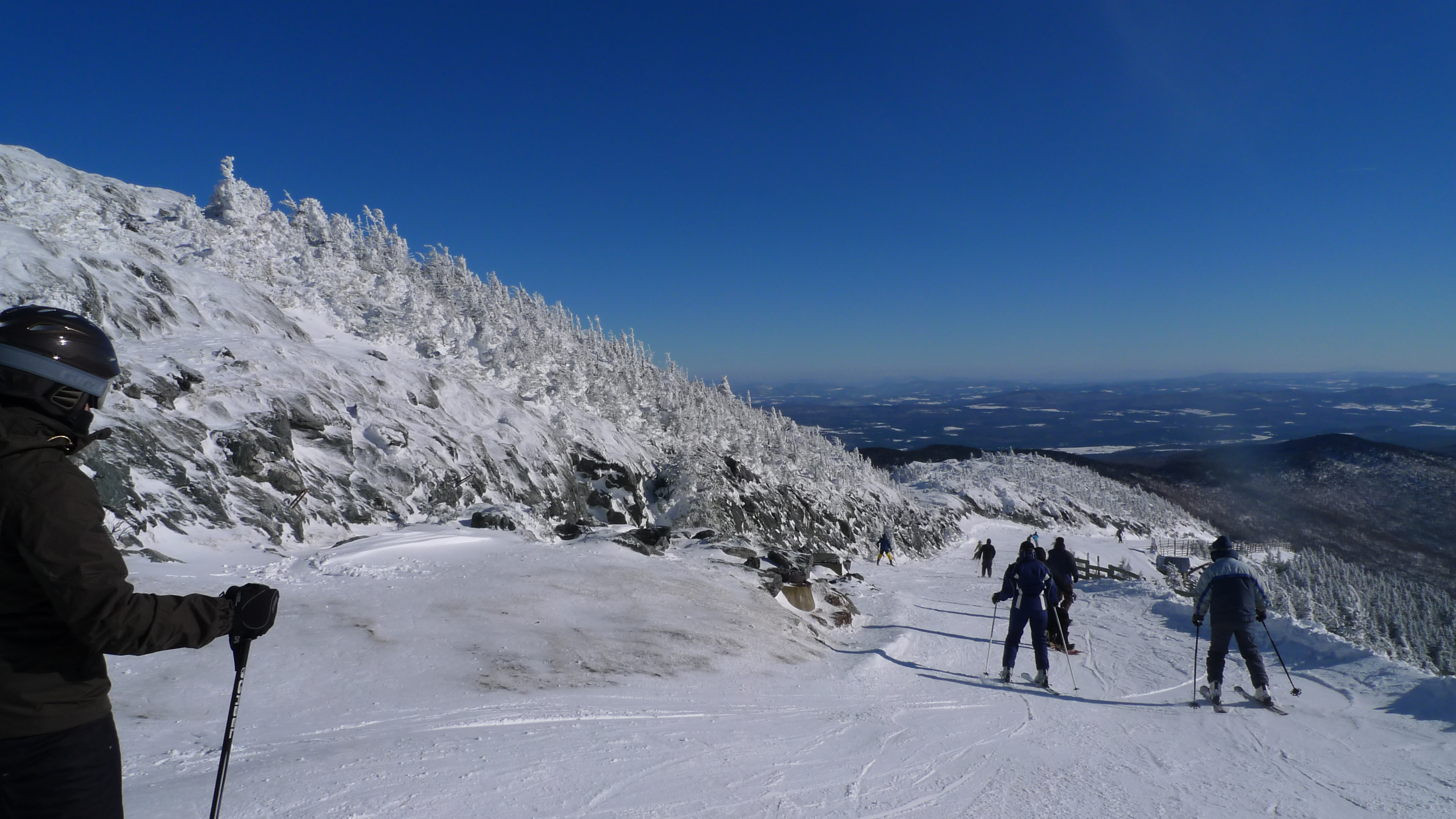
We just finished an awesome ski/snowboard trip to Jay Peak, Vermont with Rolly and Margie. Prior to this, I had only ever skied 3 days (on a single trip in Colorado), so although I’m not bad at it, I was definitely the newbie among this group of veterans.
I skied mostly blue trails and sustained no injuries despite a fair number of falls -- I haven’t skied enough to be very confident at high speeds, so on steep slopes I tend to take a defensive posture and fall as I try to prevent picking up too much speed. That’s not to say I’m always falling, because I had at least a few runs without a single fall, and my falls are always very minor...
...except for when I ended up on icy and steep black diamond trails on 2 occasions (JFK and Upper Exhibition, I’m looking at you), in which case I lost a ski and slid uncontrollably about 75 feet down the mountain. I was finally able to stop the slide, but was still in the middle of the mountain with lots more steep slope to go below me. Fortunately Kim was uphill from me so she picked up my ski and brought it down to me, while juggling flaming chainsaws.
The first day was partially a travel day, so we got in less than 2 hours of skiing. On the second day we skied pretty much the whole day, but by the third day my legs were beat, so I only skied about 90 minutes in the morning and took the afternoon off while the rest of the crew went back out. Unfortunately the last day was 40+ degrees and slightly rainy, so we started the ~9 hour drive home in the morning, rather than getting in a half-day of skiing or boarding as we had hoped.
Having only ever skied out west, and hearing a lot about the icy trails on the east coast, I didn’t know what to expect going into this trip. But Jay Peak gets about 30 feet of snow per year -- far more than many east coast resorts -- and though it was definitely somewhat icy, it was tons of fun.
The other problem I often hear about east coast mountains is that they’re overcrowded, with long waits at the lifts and little time on the slopes; but we went during the week, and it was not crowded at all. We had no waits whatsoever for the chair lifts, and the few times we took the tram we waited maybe 5-10 minutes. There were a few runs where we saw only 1 or 2 or even no other people. Jay Peak is so far north that it’s practically in Canada, so I’m sure that also helps to reduce the crowds from Philly, New York, etc.
So while it may not be Steamboat Springs, Jay Peak is pretty awesome, and much better than I might have guessed that east coast skiing could be. And a 9-hour drive is far better than a 4-5 hour flight, especially considering that a 4-5 hour flight would include at least 2 hours of hassle on each end. If money and vacation time were infinite, we’d spend much more time in Colorado, but reality makes that less feasible, so I can see us going back to Jay for more trips like this.
(Other random observations: the Jay Peak Resort is a Pepsi-serving establishment, which is always nice, and increasingly rare in my eastern-Pennsylvania experience. And they have recycle bins in the hotel rooms; I’ve never seen that before, which is kind of sad really.)
Now about that Idiot’s Guide: when I skied in Colorado for the first time, I had a lot of trouble with my rented ski boots. Apparently the little bone on the outer sides of my feet (below the little toe) sticks out more than usual, and it was really sore by the second day. I had to put moleskin on either side of the bone to take some pressure off it, and figured that I might need to get ski boots that are custom-fitted with a little cutout in that area.
But on this trip, on the first day, I instead just had lots of pain all over the lower parts of my legs that were inside the boots, even though the boots seemed to be the right size and fit OK. On the second day I went back to the rental shop to ask if they could give me different ones in the same size. They told me the original boots were new, so they were better padded and perhaps not quite broken-in yet. So they gave me last year’s version of the same model, which would be more broken-in. They seemed to feel better, but as soon as I walked and skied in them a little bit, I felt that pressure and pain on the bones on the sides of my feet. I took the boots back again, and spent some time talking to the guy at the rental place.
Ski-rental-guy led me to the source of the problem: I was wearing sweatpants under my snow pants, and the bottoms of the sweatpants were inside the ski boots. This was creating pressure points on my legs due to the extra fabric getting bunched up in the boot and then squeezed against my legs. He said that nothing except a good, thin ski sock -- and only a single pair, well-fitted to avoid wrinkles -- should be inside the ski boot. So I got the original well-padded boots back, put them on without the ends of my sweatpants inside them, and the problem was solved! I no longer had to look forward to skiing reluctantly, knowing that my feet/lower legs would be in pain the whole time.
So that’s my first tip (more of a note-to-self, really): use a well-padded ski boot and don’t let the ends of your pants/sweatpants down inside them.
The other problem I had was that my legs were dead by the 3rd day. I’m normally pretty active with exercise during the summers, but it’s harder when it’s cold outside, and I had been going for 1-mile walks a couple times a week for a couple months before the ski trip. Clearly that wasn’t enough; skiing is really hard on your legs, and it requires a lot of leg muscle to be able to exert enough control to make turns properly, and especially to be able to maintain control & quickly re-establish control while skiing in icy conditions. So tip #2 is that you (I) need to *run* a couple miles, a couple times a week, to prepare for a ski trip.
Steamboat Springs
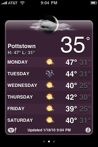
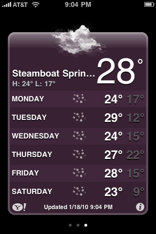
I’m super psyched for our upcoming ski trip to Jay Peak. But every time I check the conditions in Ski Lodge, this is what I see:

Dang, Steamboat. Don’t be stingy with all that snow!
Home – Create Post – Archives – Login – CMS by Encodable